Article of the Month -
September 2012
|
Meeting the Environmental Issues - A Challenge for
Surveyors and Surveying Associations
Karl-Friedrich THOENE, Germany
1) The paper summarises a
keynote presentation given at the FIG Working Week in Rome, 8 May 2012.
Key words: Global Megatrends, Land Governance, Surveying
Profession, Environment, Surveying Associations
SUMMARY
A better public perception of the surveying profession requires a
campaign to improve the general image of the profession and raise
awareness of its fundamental contribution to key socio-political issues
and global megatrends. Regarding environmental issues, such as energy
provision, climatic changes, demography, bio-diversity, societal
modernisation, disaster risk prevention and security policy, surveyors
have to act as change managers. The global footprint of the surveying
branch has to be pointed out through pro-active communication. This
paper addresses the new professional orientation for surveyors in
Germany and describes DVW´s integrative role as a platform and a
stakeholder for the entire geo-community, shaping networks between
politics, government, administration, private economy, industry,
geo-business, science, research, education and other NGO´s.
1. INTRODUCTION
Surveyors are engineers with a technical and mathematical background.
It`s beyond doubt that we enjoy a good reputation by doing our job well
and precise. However, it`s also a fact that surveying is a service
discipline in a value-added chain. Thus, usually surveyors are not
identified with the final product – in contrast, for example, to a
civil-engineer and the bridge, he has constructed. Hence, we have to
improve our communication and promotion capabilities so as to allow for
a better public understanding of the essential role of surveyors. In
regards to our serious “young blood problem” and generally the lack of
engineers in Germany, which threatens to impact seriously on the
innovative power of our economy, DVW, in collaboration with our sister
organisations, has developed an image campaign for geodesy,
geo-information and land management and their protagonists. The main
goal consists simply of making engineering sciences, especially in the
field of surveying, again more attractive for young people, who –
following a trend over the last decade – have turned towards study of
courses with better income potential. Essentially - growing demand
cannot be met by the available alumni.
Predominantly, this article is concerned with specific German
experiences pertaining to how to shape environmental and societal change
through surveying activities and how to support those processes through
a strong professional association. Further, it is assumed that many
countries face similar challenges. In this respect the presented
approach may give helpful suggestions for applicable solutions.
2. GLOBAL MEGATRENDS AND THE SURVEYING PROFESSION
The key for a better understanding is to make the fundamental
contribution of the surveying profession for regional, national and
global development visible in regards to societal megatrends and the key
socio-political issues. The allegory of the two stone masons makes the
context clear: a traveller comes along and asks the first stone mason
what he is doing there. His answer: I hew stones. The second mason,
however, answers: I am working on a cathedral!
Let’s face the main challenges of Global Change and the function of
surveyors with the ideology of the second mason, as Change Managers.
Without laying claim to completeness, those main challenges are:
- Energy
- Climate Changes/Global Warming
- Demography
- Environment
- Land Tenure System
- Modernisation of the Society
- Global Financial Crisis (banks and states)
- Disaster Risk Management
- Security (in every respect)
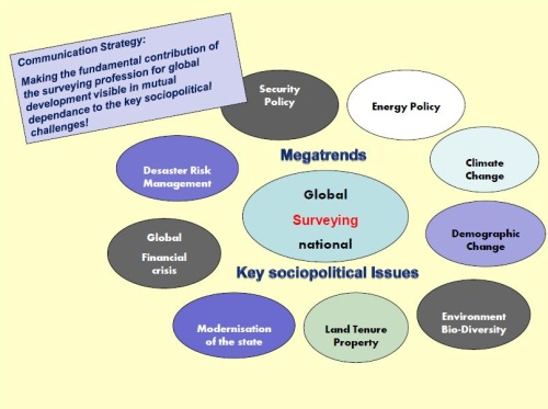
Figure 1. Global megatrends and the role of the surveying
profession
3. THE LAND QUESTION AND SUSTAINABLE DEVELOPMENT
A surveyor`s affair? Yes, of course, because it`s really all about
land! Hernando de Soto`s credo to the importance of land is of timeless
relevance (de SOTO, 2000). The successful countries will be those that
spend their energies ensuring that property rights are widespread and
protected by law, rather than those which continue to focus only on
economic policy.
The global financial crisis has proved his theory painfully and
underlines at least the role of engineers for progress and qualitative
growth – for real products and values instead of bubbles - of financial
behaviour without measure, values or morality. Thus we have to make
clear that engineering disciplines, especially in the field of
surveying, are characterised by a solid professional-ethical basis.
Accordingly, issues and virtues like sustainability and reliability are
important to us as a code of conduct. We generate real and lasting
values in terms of solutions.
Figure 2. Tim Flannery, FIG Congress Sydney 2010
Tim Flannery, one of Australia`s leading thinkers and writers
and an internationally acclaimed scientist and conservationist
(FLANNERY, 2005/2008), gave us a clear message to take with us as well
as a performance order in his great keynote speech at the FIG Congress
in Sydney, 2010. The way he sees it, surveyors are custodians of an
enabling technology that is critically important for the future.
Surveyors should take a leading role in monitoring environmental
processes – namely climate change and in explaining it to a broader
public. Indeed, a pleading for pro-active communication of our strengths
and potential.
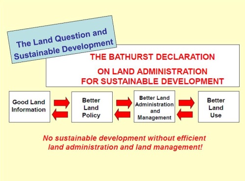
Figure 3. Bathurst Declaration
The Bathurst Declaration of FIG and the UN, 1999, focussed on
the close connection between the land question and sustainable
development: No sustainable development without efficient land
administration and land management. This especially applies to facing
environmental issues.
Willi Zimmermann, a well respected German consultant, emphasized
in his remarkable INTERGEO Karlsruhe, 2009, keynote the necessity of a
new Global Governance. Given current estimates of the world population
are at 6.8 billion and are likely to exceed 9 billion by 2035, the fight
for food, for the preservation of the natural resources of planet earth,
the fight against political and economic misuse of power and against the
lack of governance in fragile states as well as the fight for justice
and against poverty, are paramount. He demands a Global Governance in
the meaning of a broadened understanding of “Global Public Goods”
including global spatial information about the actual state and
development of global resources.

Figure 4. The Global Footprint of the Surveying Profession
The responsibility of surveyors can be described as the global
footprint of our work, including:
- land governance, land administration and land management as key
competences,
- establishment of a Spatial Data Infrastructure (SDI),
- based on geodetic reference systems,
- accompanied by professional education, research systems and
institutions and
- supported by professional associations and networks such as FIG on
a global level as well as national associations.
4. SURVEYORS AND THE ENVIRONMENTAL ISSUES - EXAMPLES
Coming back to the global challenges and their relationship with the
surveying branch, some practical examples, for relevant surveyor`s
activities concerning my professional background as the director-general
for land management and forestry in the Free-State of Thuringia, one of
the new German Laender (federal states), shall be presented proximately.
After the Fukushima disaster the German Government decided to phase-out
nuclear power and replace it with renewable energies – wood, water,
wind, solar, agricultural bio-gas etc. The radical change of the
Energy Policy results in enormous impacts on land use and property.
Land management is required for the provision of land for the requisite
facilities, for new transmission lines and for ecological compensation
as well as for the reorganisation of land ownership and land use,
including a participative approach in a close dialogue with the actors
on site.
Climate Change is in our backyard and adaption strategies are
at the top of the agenda of the land management authorities. An
interdisciplinary study group, established by the German Surveying
Association, DVW, has worked out the contribution of land consolidation
and land management for facing this challenge.
The Demographic Change in Germany (migration, “brain drain”, low
birth rate, less people which are growing older) – summarised in drastic
words: at first people don`t want to have children and finally they
don`t want to die - has amongst other serious outcomes a negative
side-effect, namely, that a decreasing population consumes more and more
land for settlement and transportation purposes. The red line in the
figure below shows the increasing land consumption over the years and at
the same time the blue line documents a meanwhile decreasing population.
The scissor is opening more and more.
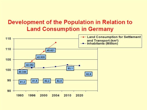
Figure 5. Decreasing population and increasing land consumption
As a counter strategy the government of the Free-state of Thuringia
has developed a Land Budget Policy. The sustainable regeneration of
brownfields instead of the on-going consumption of worthy agrarian land
is part of this strategy and is perhaps relevant for all countries in
transition. What are we talking about?
On the one hand eye-sores in our villages, heritage of the socialist era
and synonym for depression, on the other hand worthy agrarian land is
consumed for residential, infrastructural or commercial purposes.
Opencast mining areas in a large scale are under redevelopment. Half of
the nuclear arsenal of the former Soviet army was assembled with uranium
from the below documented mining area in Saxony and Thuringia. A
destroyed and contaminated landscape resulted. 20 years later, after a 5
billion Euro environmental rehabilitation programme, accompanied by
sound land reorganisation procedures, flourishing landscapes result. The
development of the village center with the help of the village renewal
programme prevents land consumption in the free landscape.
|

Figure 6. Eye-sore in a village |

Figure 7. New residential areas |
|
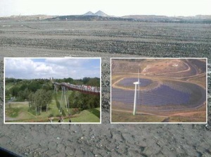
Figure 8. Mining areas under rehabilitation |
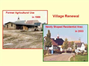
Figure 9. Village Renewal |
Environmental protection and the preservation of biological
diversity number among the key competences of rural land management.
The figure below shows a remainder of the socialist industrialised
agriculture: A slurry disposal for a 300,000 pig breeding facility,
which originally was a lake. The area was decontaminated and reshaped as
carp-breeding ponds and reserves for migratory birds through integrated
land consolidation procedures.
|

Figure 10. Slurry disposal |
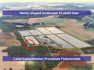
Figure 11. Ecological land consolidation |
|
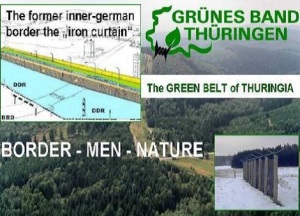
Figure 12. The Green Belt |
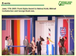
Figure 13. Event Management |
The GREEN BELT of Thuringia, the former inner-German border, the iron
curtain, is today a label for a really successful example of both, an
integrative and sustainable environmental protection initiative and an
example of good governance for regional development. The basic strategy
was and is to generate regional development from a sound environmental
state in a unique landscape as a value-added chain. The philosophy
behind this is to do this with due respect to the historical aspects and
to the interests of the local and regional players.
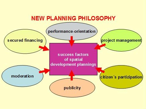
Figure 14. New planning philosophy
A lesson learnt is that surveyors definitely have to improve their
planning competences. A new planning philosophy is based on the success
of spatial development projects – land management in a broad and
integrated approach, including moderation, secured financing,
performance-orientation, project management, citizen`s participation
and, importantly, publicity and communication. Coming back to my
introduction: Do well and talk!
As part of the Green Belt Land Management Project we have organised a
mega event with the builders of the German Unity, Mikhail Gorbatchev,
George Bush Sen. and the former German Chancellor Helmut Kohl, at Point
Alpha, in times of the cold war one of the most dangerous points of the
world because all NATO and Warsaw Pact war sceneries were concentrated
on this gap, with high troop concentrations on both sides of the border.
The heraldic animals of all three nations are eagles and a falconer let
them fly over the crowd and they landed on the arms of the three
statesmen - a magic moment as well as an effective promotion for the
land management project itself.
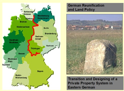
Figure 15. New Land Tenure System for Eastern Germany
As a best practise example, a private property based land tenure
system was successfully re-established after the German Reunification, a
significant challenge after the socialist anti-property era.
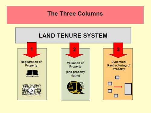
Figure 16. Land Tenure System - the three columns
The transition and designation of a private property system in
Eastern Germany is a success story which brought the societal relevance
of surveyors deeply into the minds of the people. No peace between
neighbours, no investments without clarified and regulated property -
that was and is the message!
The task included to re-establish all three pillars of a fair,
private property based land tenure system: Land Administration,
Valuation and Land Management at its best. The solution to land use
conflicts between agriculture, nature, settlement and infrastructure
improvement, which occurred with the ”Infrastructure Projects German
Reunification”, i.e., newly constructed west-east transportation
arterias, became necessary.
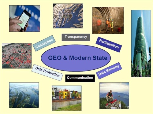
Figure 17. Geo and modern state
Geo is inside of all! This underlines the relevance of geodetic
engagement in the broad field of the modernisation of the society,
taking navigation and positioning or policy making in the form of the EU
INSPIRE directive as examples.
5. TOWARDS THE SIGNIFICANCE OF PROFESSIONAL ASSOCIATIONS – THE
EXAMPLE OF THE GERMAN DVW
Tradition and Progress – from Pharaohs to Geoinformatics, the motto
of the FIG Working Week 2005 in Cairo - for a better understanding of
the system men-earth. Our deep historical roots stand for reliability
and constancy and are inherent to the ethical basis of the surveying
profession. Take a look at NASA´s Brief History of Geodesy - a wonderful
trailer on YouTube. Our roots have to coercively become part of a
communication and promotion strategy!
DVW was established in 1871 as a professional institution and was one of
the founders of FIG. Thus, 140 years of experience in successful
professional policy is part of our branding and confidence marketing. A
long tradition symbolizes stability, continuity, reliability and
sustainability as a main feature of our engineering profession. In my
view tradition is much more than a nostalgic view back to the past. It
draws on a strong internal and outward appearance of a professional
association.
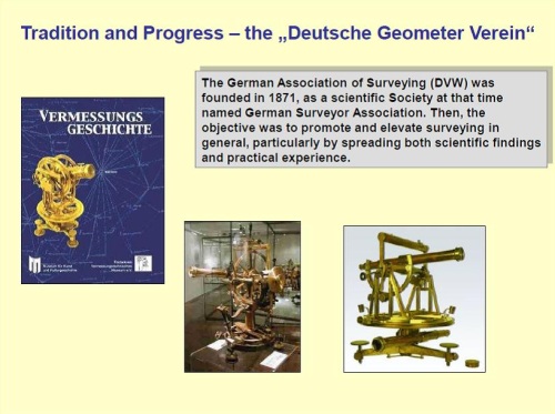
Figure 18. Tradition and Progress
DVW sees itself as the home of the surveyors in Germany, promoting
the sense of belonging together (corporate identity) and acting as a
political lobbyist for surveyor`s interests. Professionally the DVW is
arranged into 13 independent state associations, according to the
statutes.
7 expert study groups deal with state-of-the-art surveying and land
management issues on both, a national and global level.
We have published the Journal for Geodesy, Geo-Information and Land
Management (zfv) since 1873, one of the oldest technical-scientific
periodicals.
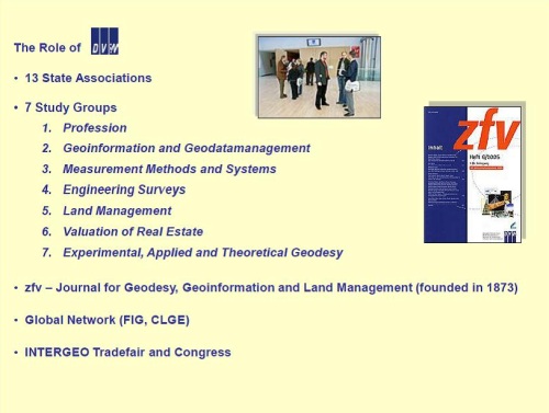
Figure 19. Organisation of DVW
DVW is involved in international matters, primarily through FIG, on
meeting the global professional challenges and responsibilities and
increasingly through CLGE, the European Council of Geodetic Surveyors,
as about 80 % of the applicable law in Germany is EU-made and a strong
representation of interests in Brussels is regarded as useful.
DVW acts as the organizer of the INTERGEO, which has emerged to become
the world’s largest event and communication platform in the developing
field of surveying from a multi-disciplinary perspective. Thus,
INTERGEO, which stands under the permanent patronage of the Federal
Minister of the Interior, is the top brand of DVW and the surveying
community. There is indeed no better forum for communication, promotion,
discussion and transportation of our professional interests to our
partners in policy, economy, government, administration, geo-business,
science, education and research than INTERGEO.
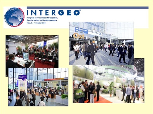
Figure 20. INTERGEO Trade Fair and Congress
Hence, we are successfully working on closer cooperation – based on a
common formal declaration - between the various sister associations,
namely:
• the Society for Photogrammetry, Remote Sensing and
Geoinformation (DGPFG),
• the Cartographic Society (DGfK),
• the Hydrographic Society (DHygG),
• the Association of German Surveyors (VDV),
• the Society of Mining Surveyors (DMV),
• the Federation of Publically Appointed Surveyors (BDVI),
• the Society for Positioning and Navigation (DGON) and
• the Umbrella Organisation for Geoinformation (DDGI).
The final goal is to establish a connected and networking
geo-associations community. The appointed range of action includes a
stronger representation of common professional interests and joint
activities in the fields of further education, recruiting new young
professionals, branding, a close coordination in the specialist work of
the association committees and the improvement of cross-industry
communication. A visible sign is a joint presentation stand of all
associated societies which, for the fourth consecutive year, will be in
the fair area at this year`s INTERGEO in Hannover, the so-called
“Geo-Associations Park”.
So the unique benefits of a strong national surveying society with a
stabile financial basis, a functioning internal organization and good
networks to partner organizations, policy and media are quite evident.
This will be achieved through professional lobbying and the capacity for
long-term strategic initiatives – like the Brand “Geodäsie” as a
corporate identity and label of confidence marketing for all surveying
activities in Germany (the German expression “Geodäsie” is not
comparable to the English “geodesy”, moreover, it includes the whole
range of surveying activities as an umbrella term).
In order to promote our profession`s key societal role and to raise
political awareness we have developed a strategy as an integrated part
of the Brand “Geodäsie” – an initiative for recruiting qualified young
people to our profession,
www.arbeitsplatz-erde.de (an English version is available) as an
appropriate reaction to a dramatic lack of new recruits for engineering
sciences in general, on the one hand, and excellent professional
perspectives for Geodesy, Geo-information and Land Management on the
other hand.
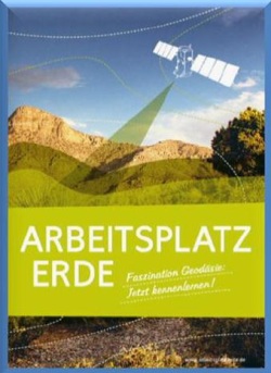
Figure 21. The new recruits Internet platform “workplace earth”
The message of the brand “Geodäsie”- initiative to our members, to
our clients and partners as well as to young people with good
mathematical and technical abilities is quite clear:
We are surveyors and we are engineers,
• vested with good virtues,
• of high societal benefit and
• provided with scientific and practical know-how.
We offer answers to the future questions of planet earth and mankind!
We want higher acceptance and a better perception of our work and our
profession.
We need a better internal outcome for our profession!
We need more young blood and we offer great job perspectives.
We are proud to be surveyors!
Hand outs of presentation at FIG Working Week 2012 in Rome, Italy
REFERENCES
De Soto, H, 2000. The Mystery of Capital: Why Capitalism Triumphs in
the West and Fails Everywhere Else. Basic Books, 2000. ISBN
0-465-01614-6.
Flannery,T, 2005/2008, The Whether Makers. The Text Publishing
Company, Melbourne. ISBN 9781 921351 822 (pbk).
BIOGRAPHICAL NOTES
President of the DVW – German Association for Geodesy, Geoinformation
and Land Management. Director-General for the Development of Rural
Spaces and Forestry, Thuringian Ministry for Agriculture, Nature
Conservation and Environment in Erfurt, Thuringia, Germany. Doctorate
(PhD) in Engineer Sciences (Dr.-Ing.) at the Technical University of
Berlin. Honorary Professor at the Technical University of Dresden for
International Land Policy and Land Management. Lecturer at the Technical
University of Munich, International Master Course „Land Management and
Land Tenure“.
CONTACTS
Prof. Dr.-Ing. Karl-Friedrich Thoene
c/o Thuringian Ministry of Agriculture, Forestry, Environment and Nature
Conservation
Hallesche Straße 16
99085 Erfurt
GERMANY
Email:
karl-friedrich.thoene@dvw.de
 |