Article of the Month -
April 2009
|
SDI Developments in the World’s Currently
Existing Mega Cities
Ms. Silke BOOS and Prof. Hartmut MÜLLER, Germany


 This article in .pdf-format
(19 pages and 389 KB)
This article in .pdf-format
(19 pages and 389 KB)
1) This paper has been prepared as
part of FIG Commission 3 WG 3.2 (Spatial Data Infrastructure) project.
Interim reports of the project have been presented at the Commission 3
Workshop “Spatial Information for Sustainable Management of Urban Areas”
in Mainz, Germany, 2-4 February 2009 and will be presented at the FIG
Working Week in Eilat, Israel, 3-8 May 2009. Final report will be
presented at the FIG Congress in Sydney, Australia in April 2010.
Key words: SDI, mega cities, City Management
SUMMARY
One objective of FIG Commission 3 focuses on promoting the use of
Spatial Infrastructure Management (SIM)-tools at different
administrative levels for decision makers and citizens to support the
goals of participatory democracy. In this context FIG Commission 3 has
set up the Working Group WG3.2 Spatial Data Infrastructures in Mega
cities, which aims at identifying relevant spatial tools to support
development and use of spatial data infrastructure (SDI) by city
authorities in the world’s largest cities. The strategy of the work
program emphasizes key problems of mega cities by reviewing SDI
developments in existing mega cities, documenting case studies,
including lessons learned about solutions for problems and should
finally lead to a toolkit for use of best practises in SDI for managing
mega cities. To complement the results of direct correspondence with
administrations of mega cities one important part of this project
concentrates on a background research of existing sources about overall
use of SDI in mega cities.
The objective of this paper is to discuss the results of an internet
search concerning the use of Spatial Information Technology in the
world’s currently existing mega cities. The search starts from a
nationwide view on the execution and the progression status of SDI’s in
the home countries of mega cities and zooms in to the specific aspects
of spatial data management in the metropolitan areas of special
interest. As a result we come to the conclusion, that current SDI
development in mega cities covers the whole range from first stage
conceptual ideas up to an almost complete operational SDI availability.
1. INTRODUCTION
In 2007 FIG Commission 3 has originated the Working Group WG3.2
Spatial Data Infrastructures in Mega cities, which proposes to identify
relevant spatial tools that will support development and use of spatial
data infrastructure (SDI) by city authorities in the world’s largest
cities. In this context the working group has adopted a pragmatic
approach, based on working with administrations in mega cities to
identify key problems they face both nowadays and in the future.
Furthermore it is planned to access an international network of
experienced spatial information practitioners to identify solutions and
in a last step to develop materials which will provide for a toolkit of
SDI best practices to be used for the purpose of city management. Until
now the working group has developed a questionnaire about current
problems facing mega cities and their current use of SDI, which was
distributed in early 2008 to city administrations in 13 mega cities
(Kelly, 2008). Supplementary and independently to this direct
correspondence one important objective is to undertake background
research including a literature and internet investigation of existing
sources to gather information about use of SDI in mega cities.
This paper presents the results of an internet investigation, which
collected information about use of SDI in the world’s largest
metropolitan areas. A metropolitan area in this context is defined as an
urban agglomeration with more than 10 million inhabitants, which by now
is true for 26 cities in the world (http://www.citypopulation.de/world/Agglomerations.html).
The following sections provide at first a short overview of general NSDI
development for all countries of the world holding at least one mega
city. According to that countrywide view the use of SDI or comparable
initiatives in the associated metropolitan areas is being described.
The last section of the article conducts an evaluation of the results
of the internet investigation. Leaving legislative and organizational
SDI aspects aside the evaluation constrains on the technical aspects of
the use of spatial information technology in mega city management. The
results of the study are given in form of a classification of different
development stages existing both at national and urban levels. The
classification is done on basis of usability and accessibility of
spatial data which could be identified by the internet search.
2. APPLICATION OF SPATIAL INFORMATION TECHNOLOGY IN MEGACITIES AND
THEIR HOME COUNTRIES
2.1 SDI application in the African Region
NSDI in Egypt is still rudimental and has to deal with a
number of bottlenecks such as weakness of partnerships, lack of digital
data and metadata, absence of a clear institutional framework, shortage
of access and sharing mechanisms to search for data, lack of national
standards and also a scarcity of qualified specialists.
Considering the underdeveloped NSDI of Egypt it is no surprise, that
for the city of Cairo no information concerning SDI development
or comparable initiatives could be found.
Nigeria started the implementation of a National Geospatial
Data Infrastructure (NGDI) in 2003. The policy statement to guide the
operations of NGDI covers the following items:
- Facilitate cooperation and collaboration among stakeholders in
generating Geospatial Databases for development of SDI at National,
State and local levels in Nigeria.
- Eliminate duplication in the acquisition and maintenance of
Geospatial data.
- Establish institutional, legal, technical and administrative
frameworks for
- a consistent and harmonized mechanism for geospatial data
distribution
- easy access to vital geospatial datasets and their efficient
sharing and exchange
- integration of datasets through the application of common
standards
- Promote investments in the production of geospatial databases.
- Promote research, training, education and capacity building
related to geospatial data production, management and usage.
In 2007 the government of Lagos state constituted a committee
for the provision of a fully digital mapping and enterprise GIS for
Lagos State. The policy framework adopted by the administration for the
development of Lagos State should be reached by generation and sharing
of information with organised private sector, developing skilled and
knowledgeable workers. The mapping products that should be delivered as
a result of this project should be at the scale of 1:500 for
metropolitan Lagos and at 1:1.000 for rural areas. Other scheduled
products include: orthophotos (scale 1:2.000), contour lines (scale
1:500 for urban and 1:1.000 for rural areas) and Digital Elevation
Models.
2.2 SDI application in the Asian-Pacific region
In Bangladesh no official NSDI exists. SDI conform initiatives
were initiated by the “Bangladesh Society of Geoinformatics” in 2006.
Its mission is to build up capacity in Geoinformatics within
governmental and non governmental agencies and to guide and assist the
distribution of Geoinformation technology, sharing of ideas, information
and knowledge among users, professionals and institutions. One of the
objectives is to promote and assist establishment of the National
Spatial Data Infrastructure (NSDI) in Bangladesh.
In accordance with the rudimental national SDI initiatives in
Bangladesh also in Dhaka neither city SDI nor any WebGIS
application or similar could be identified.
China has paid great attention to construct the Digital China
Geospatial Framework (DCGF). This NSDI has four layers at National,
Provincial, Municipal and County level. A series of fundamental
geospatial databases was completed as the kernel of DCGF. A fully
digital nationwide geospatial data production system is widely
established. The national coordinating mechanism is in action to
strengthen the cooperation and data sharing and the national standards
are getting more complete to support the DCGF (Li et al. 2008).
In 2002 the Shanghai Municipal Government announced the
“Digital City Shanghai” strategy. In this context a distributed WebGIS
application for managing landscape resources was developed (Zhu et al.
2005), which allows the connection of all landscape bureaus of the city
where data are kept locally for maintenance and updates. These data are
also available online to the central bureau and other local bureaus.
Beyond data exchange functions the GIS provides for spatial analysis
functionality like distance-based spatial queries, for selection
functions and for different types of buffering functions.
In 2004 the city authority of Guangzhou, the capital city of
south China, initiated the Digital Municipality of Guangzhou (DigiM.GZ)
project, which is scheduled for a life span until 2010. The project aims
to represent the Guangzhou metropolitan area as a digitalized virtual
municipality by using a wide range of up-to-date GIS and
telecommunications technologies. When in use it shall provide for a
universal platform to deal with all digital data relevant for city
planning, management and maintenance, including water, gas and power
supply, transport network, drainage and telecommunications.
In Beijing the Beijing Digital Green Management Information
System is available, which consists of a GIS, remote sensing data, 3D
virtual simulation, database, high-speed broadband networks and other
hi-tech products. It integrates a database of Beijing landscaping areas
and a database of social, economic, ecological and urban infrastructure.
This system is constructed of components for integrated Management,
system maintenance, dynamic garden inspecting, integrated query,
planning, building maintenance, environmental benefits evaluation, 3D
simulation, and other subsystems.
The NSDI scheme in India (established in 2001) aims at using
GIS to merge satellite imagery and ancient topographic maps with data on
water resources, flooding, rainfall, crop patterns, and civic layouts to
produce 3-D digital maps. NSDI should, once ready, act as an online
database to maintain spatial data layers and base maps in an easily
retrievable form. 40 major cities should be mapped at a scale of 1:1000,
and in later phases the entire country should be covered. Another
objective of the Indian NSDI is to achieve a national coverage of all
forest maps, land use, groundwater and wasteland maps, pollution data,
meteorological department's weather-info and department of ocean
development's sea maps. The key elements for development of NSDI are:
standards (to enable interoperability; standards for network, gateways,
protocols etc.), evolving metadata, nodes (GIS-based spatial database
servers), search and access protocols, electronic clearing house,
creating user interfaces, and initiating an NSDI outreach and awareness
program. For these purposes India has developed a Geoportal.
In 2005/06 in the handni Chowk area of the walled city of Delhi,
which covers an area of about 20 km² size, a pilot study on generating a
3D-GIS database was accomplished. The database was created by using a
base map at scale 1:2500, high resolution satellite data, ground control
points, videos of the area, high resolution DEM from LiDAR/ ALTM and by
3D GIS data processing and analysis software. In the future the database
should be expanded for the entire city and should provide for a basis
for monitoring the city and for development of different applications
for urban planning.
In Mumbai various GIS applications for small areas with
different aims have been made. The Mumbai Metropolitan Region
Development Authority (MMRDA) recognized the usefulness of this
technology and thus proposes in its Regional Plan (1996-2011) to build
up a Regional Information System where the spatial and related attribute
data should be organized and shared among the local authorities,
planning agencies and other institutions working in the region. One of
these developments should be taken by the Collective Research Initiative
Trust (CRIT), who plans to generate an open-access spatial data
infrastructure and a set of simple tools and applications for knowledge
transfer and participatory urban planning by communities and citizens in
Mumbai. Until now the normal Internet user has only access to a demo
version with some basic spatial data.
During the Survey and Mapping National Coordination Meeting in 2000,
ISDI, the Indonesian SDI was declared to become a primary
solution to solve the problems of the availability of and access to
geospatial data (Abdulharis et al. 2005). Bakosurtanal is the
coordinating agency for the development of Indonesian NSDI (Arief
Syafi’I, 2006). The NSDI aims at improvement of coordination mechanism,
completion of spatial databases and national metadata developments,
activation of national clearinghouse (Puntodewo et al. 2007) and
development of Digital Indonesia. Agency’s spatial databases should be
completed and should work within a nationally and globally integrated
distributed system. A national clearinghouse prototype and a metadata
gateway should be developed and metadata servers should be installed in
key agencies.
The city of Jakarta provides for a very simple WebGIS
application, which represents the road network of the city and enables
different search functions to find streets and points of interest. No
further SDI-activities in the city were recognized.
In Iran, national organisations, ministry and municipal
offices as well as private companies are active in the field of mapping
and geographic information production. The national organisations
concentrate their efforts on small-scale base mapping of the whole
country. Governmental surveying offices and private companies are mostly
involved in high resolution geographic information production needed for
national and provincial projects (Baktash 2003). Most research in the
fields of photogrammetry, remote sensing, GIS and digital mapping is
carried out in the national organisations, institutions and universities
(Rad et al. 2004). However, a few private companies also made remarkable
research efforts for commercial products and services.
The Tehran municipality, Public & International Relations
Department committed to the development of a WebGIS with more than 140
layers, which should be launched before the end of the current Iranian
year. The application should serve citizens and managers of various
organisations and institutions as well as domestic and foreign tourists
with needed information.
In Japan the NSDI is implemented by the Geographical Survey
Institute (GSI) and different ministries, who began their work on the
Spatial Data Framework in 1995 and completed it in 2003. Over the period
of development the institutions produced a collection of base maps,
notably the topographical map series of 1:25.000, which covers the whole
country. Those maps were used for generating several public and private
sector maps like administration area maps, road maps and also several
thematic maps (Land Use Map, Land Condition Map, Volcanic Land Condition
Map, Map of Active Faults in Urban Area, etc). Beyond these maps also
aerial photographs were published and the development of a national
standard was established. The future work of the Japanese NSDI
concentrates on a new infrastructure concept, which is promoted as
"Digital Japan" and which shall lead to a virtual and real-time
representation of the land realized by integrating geographic
information of various kind and which shall be made accessible to anyone
on the internet.
Concerning the two Japanese mega cities Osaka and Tokyo
the internet investigation could not extract any specific
SDI-initiatives. Both cities developed long-term master plans, where
principal goals for city planning are formulated but no SDI strategy
could be identified.
The first phase of a NSDI Master Plan for South Korea was
completed by the year 2000. The main purpose of the first phase was to
establish basic GIS infrastructure by producing various kind of digital
maps. The second phase of the NSDI, which started in 2001, concentrated
on spreading GIS applications for maintaining the digital maps and
developing national standards (Han et al. 2001).
The city of Seoul has at its disposal a widespread SDI on the
technical base of several distributed GIS applications like Urban
Planning Information System, Road Information System, Soil Information
System, and other municipal affairs Information Systems. A Spatial Data
Warehouse is available which provides for sharing and accessing the
different geospatial data of the GIS systems via a GIS Portal system. A
map viewer program even allows analyses of the retrieved data.
Up to present in Pakistan no official NSDI was established.
Only some SDI-supporting-initiatives exist (Asmat 2008), one from which
should be mentioned as the Winner of GSDI Association Small Grant
2006-7. Under the aegis of the WWF this initiative develops a SDI for
sharing environmental information. From the inception of the project
large amounts of geospatial data including satellite imagery, digital
vector data, and digital terrain models were acquired and developed.
In its “Megacities Preparation Project” from 2005 Karachi’s
government schedules the development of digital maps of the city by
using GIS technologies. Yet this project could not be finalized.
First official activities for establishing a NSDI in Philippines
were initiated in 2001 under the umbrella of the National Geographic
Information Council (NGIC). The central mapping agency of the government
of the Philippines (NAMRIA) keeps all base maps such as topographic maps
in different scales, aerial photographs and satellite images. NAMRIA
also produces different thematic maps such as for land condition, land
cover, land use, planimetric and administrative maps.
As a member of a developing country Metro Manila has not yet a
comprehensive SDI available. A Disaster Management Information System
called “Metro Manila Map Viewer” was developed in 2004, which allows
users to retrieve useful information and maps from datasets including
hazards, transportation, public facilities, emergency services,
elevation, land use/zoning, and high-resolution imagery.
In 2004 a feasibility study on NSDI was initiated by Geo-Informatics
and Space Technology Development Agency (GISTDA) with grant support from
the U.S. Trade and Development Agency (USTDA) for Thailand. The
study could show various problems particularly concerning data sharing
and data usage. Development of NSDI fits in very well with the Thai
Government’s scheme on a comprehensive utilization of Information
Technologies to support administration and public services. The key
mechanism is the development of e-Government in which GIS forms a key
component which plays an important role in providing for dynamic
information to support better governance of the country. A collection of
geospatial data are available from the Royal Thai Survey, which provides
for data in analogue and digital format (information available only in
Thai language).
For the city of Bangkok only a webpage in Thai language could
be found. This webpage seems to grant access to a comprehensive
collection of geospatial data in different GIS applications.
2.3 SDI application in the European region
As Francois Salgé states’France is creating a NSDI without knowing
it. Thus NSDI is not per se an issue in the French context’ (www.ec-gis.org/ginie/sdi_ws/france.ppt
) Consequently there is no explicit overall governmental initiative to
develop an NSDI in France even though a Geo- Portal was launched in 2006
and a multitude of NSDI-like initiatives are being undertaken.
In Paris a WebGIS application gives access to the most
important geospatial information about the city. It is possible to
access a series of thematic maps through a multiplicity of data layers
Russia is just at the beginning in developing a NSDI. The
concept dating from 2006 schedules a three stage process, which should
be finalized by 2015 with the implementation of the national NSDI. The
concept shall be transferred into a distributed system for collecting,
processing, storage and delivery of basic geospatial data and metadata.
The system shall comprise subsystem levels of government and local
governments and shall users grant remote access to digital databases of
geospatial data and metadata.
For the city of Moscow no specific SDI solution information
could be found during the internet investigation.
Currently, the Military Mapping Agency of Turkey is the main
data producer of spatial data and has the most visible internet presence
offering limited metadata for its own products. There are several
persisting problems in the field of SDI in Turkey: lack of coordination
between institutions; no standardization, neither with regard to the
spatial reference system, nor to data quality or data exchange; data
duplication; the majority of large scale data not available in digital
format; interoperability does not (yet) exist; lack of expert personnel
and budget; and a lot of difficulties to share data.
Istanbul's Water and Sewerage Administration (ISKI) developed
the Infrastructure Information System (ISKABIS) to control and manage
extensive water and wastewater facilities for the Istanbul Metropolitan
Area. The system is based on a file server system application to achieve
effective data sharing. Within the file server system various folders
like maps, raster, infrastructure, superstructure, planning projects
etc. are categorized in a similar way as a digital library. Each
department in ISKI, such as mapping dept., GIS dept., Water Project
dept., Sewerage Project dept. etc, has to update exclusively the folder
which it is responsible for. More than 30 applications are implemented
in ISKABIS CAD/GIS program. Ultimate Map Management, Infrastructure
Management, Projects Management, Address Query, Building Query,
Cadastral Query, Geographical Information System Applications, Easy
Print Utility etc. can be made via ISKABIS.
The city administration of Istanbul provides for a WebGIS, which
represents the road network for the metropolitan area of Istanbul
containing a precise division into lots and house numbers, orthofotos of
different years and a range of thematic information, as well.
Although in 1995 the National Geospatial Data Framework (NGDF)
initiative was launched, there is yet no formal NSDI in the UK,
or a single organization with responsibility for its establishment and
coordination. On the other hand, the country as a whole has a well
developed GI sector, with extensive datasets available from both public
and private sector sources (McLaren et al, 2000). Various efforts have
been undertaken to implement a broad metadata service but these have not
been sustainable.
The government of the city of London provides for the City
Online Maps Project Accessing Spatial Systems (COMPASS), which aims at
improving access to information about the city of London through a
unique access point so that residents and those visiting the city are
better informed. A wide range of data is available on the site such as
where to find your nearest services and information about planning
policies affecting the city. One remarkable SDI conform application in
London is the Newham Neighbourhood Information Management System (NIMS),
where users gain access to data on economic, social and environmental
conditions of the borough. Maps, charts, data download is available, as
well as generating of online reports and performance information.
2.4 SDI application in the Pan American region
In 1998 the first activities concerning NSDI were initiated in the
federal republic of Argentina by the SIGRA group (Geographic
Information System of the Argentine Republic) and the National Mapping
Agency (IGM) leading to the NSDI implementation in 2001. In 2005 the
National Geographic Information System of the Republic of Argentina
(PROSIGA) started as an Internet distributed GIS, in which seven
specific SDI working groups are present: Institutional framework, Policy
and Agreements, Fundamental and Basic Data, Metadata and Catalogues,
Diffusion and Communication, Training, Search Engine for Geographic
Names and IT for SDIs.
The department of Geographic Information Systems of the city
administration of Buenos Aires developed a widespread WebGIS
application built up on open source components and integrating a
multiplicity of geospatial data of the city. The GIS covers a range of
applications like health, education, tourism, sports, culture, leisure,
green spaces, social services, transportation etc. and enables access to
information up to parcel units (currently it is possible to view for
most of the parcels a photograph showing the parcel-related buildings).
The department also provides for thematic maps, which are based upon the
GIS data and can be ordered in digital or analogue format.
In Brazil the Ministry of Budget Planning and Management is
responsible for the Brazilian NSDI, with strong participation of the
Brazilian Institute of Geography and Statistics (IBGE) and the National
Institute of Space Research (INPE). The Brazilian cartographic
community, in particular Federal Government agencies, made great efforts
to constitute a NSDI in Brazil. The IBGE launched map servers offering
diverse information and providing for geodata of the whole country.
The department for planning of the city of Sao Paulo makes an
internet portal available, which enables access to a multiplicity of
statistical data, thematic maps and also allows for the vizualisation of
infrastructural data in a WebGIS client.
For Rio de Janeiro the department of city planning offers
digital maps and databases of the municipality of Rio in a Geoportal and
also allows for download of statistical tables, maps and spatial data.
Mexico’s NSDI initiative is called the “Infraestructura de
Datos Espaciales de México” or IDEMEX. The Mexican NSDI implementation
is led by the National Institute of Geography, Statistics and
Informatics (INEGI) since 1997 (Albites 2008). INEGI developed an
internet presence (GeoPortal), where users can view and download a
series of geodata, including appropriate metadata (Ramírez 2005). The
Interactive Atlas Nacional de Mexico (ANIM) on this website shows in an
exemplary way the provision of public information. The user is capable
of viewing geographical information from various sources through a
single interface.
For the Mexican mega city Mexico City the internet
investigation did not extract any specific SDI-like-initiative.
The United States clearinghouse was established in 1994 with
the US Federal Geographic Data Committee (FGDC) responsibility of NSDI
implementation (Clinton 1994). In 2004 still the NSDI major development
focus was almost completely restricted to the United States federal
level (Steven 2005). Geospatial Data are provided in a nationwide
Geoportal offering a multiplicity of functions to access, publish and
share geospatial data in a widespread number of categories.
Concerning city SDI initiatives in 2008 the New York City
government has published its IT strategy for the next years (NYC
PlanIT). The strategic plan describes a framework for how the City will
leverage general information technology in the years ahead to improve
New Yorkers’ lives. Especially the plan discusses the utilization of
spatial data. By now an Interactive City Map of New York provides for
information on the topics transportation, education, public safety,
resident service and city life. The office of Emergency Management
operates a GIS, which maps and accesses data — from flood zones and
local infrastructure to population density and blocked roads — before,
during, and after an emergency case. Beyond that the City government
runs a spatially-enabled public website called ACCESS NYC, which has the
capability to identify and to screen for over 30 City, State, and
Federal human service benefit programs to explore appropriate services
for the individual users needs.
The Los Angeles government publishes a collection of
interactive maps containing information on traffic, parcels, flooding,
city services, leisure etc.
3. ANALYSIS OF SEARCH RESULTS
3.1 Valuation method for the classification of results
From the internet investigation a wide range of different development
stages of geospatial data handling in the examined countries and their
associated mega cites emerged. Certainly this reality basically is
determined by different social, economic and political conditions given
in different countries and cities. In such a context global comparison
of the results is difficult. Thus formal criteria have to be defined in
order to set an objective evaluation framework. The main focus of the
evaluation concentrates on the technical part of geospatial data
handling while omitting the institutional and legislative SDI aspects.
The evaluation framework consists of five categories which are designed
to classify all investigated items. The list of items not only contains
the mega cities themselves but also their home countries, because a city
is part of a country and, therefore, should be part of the NSDI of its
mother country, as well.
If, for whatever reason, only few information on an item could be
found on the web, the corresponding item was marked with ‘SDI
development status unknown’. If initial activities towards SDI
development were observed the status ‘SDI master plan available’
was given. Further definition of the classification schema
differentiates primary from secondary geospatial data. Primary
geospatial data are original data, like survey data, data with limited
interpretation like water bodies or boundaries, which are obtained
without analysis or very less interpretation. Secondary data are
thematic data which are derived from the analysis of primary data,
statistical data collection and/or image interpretation. This
differentiation is in accordance with the GSDI Cookbook (http://gsdi.org/docs2004/Cookbook/cookbookV2.0.pdf),
with the guidelines of the European INSPIRE initiative (http://inspire.jrc.ec.europa.eu/)
and with the Australian Spatial Data Infrastructure (http://www.anzlic.org.au/policies.html)
which all define primary data in terms of ‘Fundamental Data’ or
similarly ’Global -’, ‘National -’, ‘Framework -’, ‘Base -’ , ‘Reference
-’, and ‘Core Data. Even if the requirements concerning geospatial
information are considerably different at national and urban level, the
overall differentiation in ‘primary spatial data available’ and ‘secondary
spatial data available’ provides for a common basis for
classification.
Another important finding of the internet investigation was the fact
that the process of SDI development in many of the searched countries
and cities currently is in the stage of digital data production.
However, the captured data often are not yet available via a Geoportal
or a similar distributed web application. To reflect this finding the
classification schema differentiates between availability of geospatial
data and accessibility of data.
Therefore, the final classification schema consists of five
categories
- SDI development status unknown
- SDI master plan available
- Primary spatial data available
- Secondary spatial data available
- Spatial data accessibility available
The following sections present the results of the internet
investigation separately for the home countries of mega cities and for
the mega cities themselves
3.2 Application of Spatial Information Technology in the home
countries of mega cities
Regarding the progress of geospatial data handling in the home
countries of mega cities the result of the internet investigation shows
a large diversity (Tab. 1). Some countries like Russia or Nigeria are
just at the beginning of developing a NSDI, while other countries are at
the stage of producing primary data (e.g. Iran, Pakistan) and also
secondary data (e.g. China, Japan). It also can be shown, that the
progress in developing a NSDI is well advanced in Europe and Pan-America
and India, where users already have access on geospatial data via
distributed web applications.
3.3 Application of Spatial Information Technology in the mega
cities of the world
The internet investigation of the status of geospatial data handling
in the mega cities proved to be more difficult than for the counties
hosting mega cities because less publication does exist concerning this
topic. Moreover, some of the cities only provide information in their
national language, which, due to lack of language ability of the
authors, could not be analyzed. . Nevertheless it can be stated that
like in the home countries of the mega cities the application of spatial
information technology in the mega cities of the world is largely
diverse. Tab. 2 shows the availability of digital geospatial data in the
considered mega cities. The application of spatial information
technology in the cities under consideration varies from the provision
of very simple WebGIS applications which only show the road network and
some less basic information like in Jakarta or Mumbai over applications
which enable the presentation of social, economic, ecological and urban
information related to the city (e.g. Buenos Aires, Los Angeles, Paris)
and ending up with comprehensive distributed information systems which
can be found e.g. in Seoul, London or New York City.
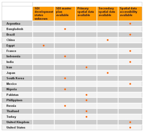
Tab 1: Application of SDI in the home
countries of mega cities
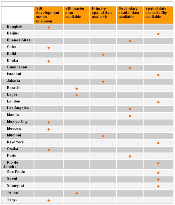
Tab 2: Application of SDI in the Mega Cities of the world
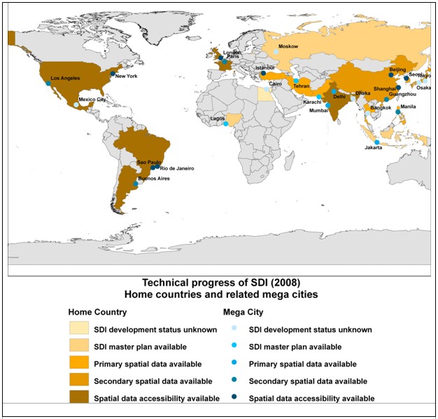
Fig. 1: Technical progress of SDI 2008 in
the mega cities of the world and their related home countries
4. CONCLUSIONS AND FURTHER WORK
The investigation results of current application of state-of-the-art
SDI technology in the world’s existing mega cities including NSDI
development in their home countries show a large diversity in terms of
progress. Whilst for some countries and cities almost no usable
information could be retrieved from the web others are in the conceptual
phase of SDI
development. Often does an analogy between NSDI progress and urban
SDI development occur (Fig. 1). In some regions primary and secondary
data production is in progress. The most advanced SDI implementations
are to be found in some countries and cities where web based services
for access to distributed spatial data pools are already in operation.
To get a more specific insight into the conditions in the different
regions of the world it could be desirable to refine the defined five
categories classification schema. In any case, the technology oriented
approach of this study should be completed by other investigations which
are to explore the organisational and legislative aspects of SDI
implementation including their interaction with planning and other
management activities in mega cities
REFERENCES
Abdulharis, R., van Loenen, B., Zevenbergen, B. (2005): Legal Aspects
of Access to Geo-Information within Indonesian Spatial Data
Infrastructure. ISPRS Workshop on Service and Application of Spatial
Data Infrastructure, XXXVI (4/W6), Oct.14-16, Hangzhou, China.
Albites, F.A.H. (2008): Relationships of Cartography, Geographic
Information Systems and the Mexican Spatial Data Infrastructure
(IDEMEX). The International Archives of the Photogrammetry, Remote
Sensing and Spatial Information Sciences. Vol. XXXVII. Part B4. Beijing.
Arief Syafi’I, M. (2006): The Integration of Land and Marine Spatial
Data Set as part of Indonesian Spatial Data Infrastructure Development.
Seventeenth United Nations Regional Cartographic Conference for Asia and
the Pacific. Bangkok.
Asmat, A. (2008): Potential of Public Private Partnership for NSDI
implementation in Pakistan. Master-Thesis, Enschede.
Baktash, P. (2003): National and Regional Spatial Data Infrastructure
(NSDI & RSDI) and
National Cartographic Center of Iran’s Activities about it. Proceedings
of the 2nd FIG Regional Conference, Marrakech, Morocco.
Cheng, P., Rao, J. (2006): Digim.GZ -- The Digital Municipality of
Guangzhou Project.
Clinton, William (1994): Coordinating Geographic Data Acquisition and
Access: The National Spatial Data Infrastructure. Executive Order 12906,
April 13, 1994, Federal Register, 59 (71), pp.17671-17674.
Han, S., Cho, H. (2001): Development of National Spatial Data
Infrastructure in Korea. Proceedings of the Technical Conference during
the FIG Working Week. Seoul, South Korea.
Kelly, P. (2008): Current Problems and Issues in Using SDI in Mega
cities. Report of FIG Working Group 3.2: Spatial Data Infrastructures in
Mega cities, unpublished.
Li, P., Lan W., Xuenian X. (2008): SDI in China: Progress and issues.
The International Archives of the Photogrammetry, Remote Sensing and
Spatial Information Sciences. Vol. XXXVII. Part B4. Beijing 2008.
McLaren, R., Mahoney, R. (2000): NSDI in the UK.
http://www.fig.net/pub/proceedings/prague-final-papers/mclaren.htm.
Quo Vadis - International Conference FIG Working Week 2000, 21-26 May,
Prague.
Puntodewo, Nataprawira, R. (2007): Indonesian Geospatial Data
Clearinghouse. Proceedings of the 3rd FIG Regional Conference, Jakarta,
Indonesia.
Rad, A.E., Sarpoulaki, M. (2004): Islamic Republic of Iran National
Report for Photogrammetry and Remote Sensing 2000-2004. Proceedings of
ISPRS Commission VI, ISPRS Congress. Istanbul.
Ramírez, J.O. (2005): The Spatial Data Infrastructure of México
"IDEMex". From Pharaohs to Geoinformatics, FIG Working Week 2005 and
GSDI-8, Cairo, Egypt April 16-21.
Steven, A.R. (2005): The US National Spatial Data Infrastructure:
What is new? ISPRS Workshop on Service and Application of Spatial Data
Infrastructure, XXXVI(4/W6), Oct.14-16, Hangzhou, China.
Zhu, Y., Yang, C., Wong, D.W., Kafatos, M. (2005): A Distributed GIS
for Managing Shanghai Landscape Resources. Geographic Information
Sciences, Vol 11, No. 1.
INVESTIGATED WEBSITES
Argentina
http://www.sig.gov.ar/
http://www.gsdi.org/GSDI10/papers/TS11.4paper.pdf
http://www.gsdi.org/newsletters/sdilacv4n12english.pdf
Buenos Aires
http://mapa.buenosaires.gov.ar/sig/index.phtml
Bangladesh
http://www.bsgi-bd.org/Index.html
Brazil
http://gis.esri.com/library/userconf/proc03/p1140.pdf
http://www.dpi.inpe.br/gilberto/papers/camara_sdi_brazil.pdf
http://www.gisdevelopment.net/policy/gii/gii0024.htm
http://www.geominas.mg.gov.br/
http://mapas.ibge.gov.br/
Sao Paulo, Rio de Janeiro
http://sempla.prefeitura.sp.gov.br/mapasedados.php
http://www.armazemdedados.rio.rj.gov.br/
China
http://www.sbsm.gov.cn/pcgiap/tsukuba/seminar/paper_cn.pdf
http://sedac.ciesin.org/china/
Guangzhou, Beijing
http://www.otitan.com/info/20071219/20071219135109.shtml
http://www.gisdevelopment.net/application/urban/overview/ma06_197.htm
Egypt
http://www.gsdi.org/docs2007/GSDISmGrtSums06-07.pdf
http://www.mapmiddleeast.org/magazine/2006/jan-feb/32_1.htm
France
http://inspire.jrc.ec.europa.eu/reports/stateofplay2006/rcr06FRv73.pdf
http://www.geoportail.fr/
Paris
http://paris-a-la-carte-version-pl.paris.fr/carto/mapping
India
http://www.mycoordinates.org/indias-nsdi-july06.php
http://gisserver.nic.in/nsdiportal/gotogos.jsp
http://www.gisdevelopment.net/news/viewn.asp?id=GIS:N_npqesowhvy
http://www.gisdevelopment.net/application/urban/overview/urbano0005a.htm
Delhi, Mumbai
http://www.gisdevelopment.net/news/viewn.asp?id=GIS:N_xplqdkajin
http://www.gisdevelopment.net/magazine/years/2007/april/32_1.htm
http://www.mmrdamumbai.org/planning_information.htm
http://crit.org.in/category/mapping/
http://mumbai.freemap.in/
Indonesia
Jakarta
http://map.yellowpages.co.id/Default.aspx
Iran
Teheran
http://www.tehran.ir/Default.aspx?tabid=5215&ctl=Details&mid=22486&ItemID=23030
Japan
http://www.gsi.go.jp/
http://www.nsdipa.gr.jp/english/pof.html
http://www.geoinfo.ait.ac.th/download/SCOSA2007/2_MrKawase/NSDI.pdf
Osaka, Tokio
http://www.city.osaka.jp/english/more_about_osaka/city_concept/index.html
http://unpan1.un.org/intradoc/groups/public/documents/APCITY/UNPAN015060.pdf
South Korea
Seoul
http://gis.esri.com/library/userconf/proc06/papers/papers/pap_2000.pdf
http://english.seoul.go.kr/government/ICSFiles/afieldfile/2005/03/25/GIS.pdf
Mexico
http://www.inegi.gob.mx/inegi/default.aspx
http://gis.esri.com/library/userconf/proc03/p1140.pdf
Nigeria
http://www.rectas.org/NigeriaGIpolicy.pdf
Lagos
http://www.tundefashola.com/archives/news/2008/07/15/20080715N01.html
Pakistan
http://www.esmap.pk
Karachi
http://www.adb.org/documents/produced-under-ta/38405/38405-pak-dpta.pdf
http://www.dailytimes.com.pk/default.asp?page=2007\09\25\story_25-9-2007_pg12_3
Philippines
http://www.geoinfo.ait.ac.th/download/SCOSA2007/4_SDI_Activities_by_countries/6_
Philippines.pdf
http://www.geom.unimelb.edu.au/research/SDI_research/Integrated/Int_Template_
Philippines.pdf
http://www.namria.gov.ph/home.asp
Manila
http://www.pdc.org/mmeirs/html/mmeirs-home.jsp
Russia
Moscow
http://www.gisa.ru/
Thailand
http://www.gisdevelopment.net/policy/international/ma04013pf.htm
http://www.rtsd.mi.th/service/
Bangkok
http://www.bangkokgis.com/
Turkey
http://inspire.jrc.ec.europa.eu/reports/stateofplay2006/rcr06TRv91.pdf
Istanbul
http://iskabis.iski.gov.tr/ENGLISH/be_awards2007/awards.html
http://sehirrehberi.ibb.gov.tr/MapForm.aspx?&rw=1E7&cl=4F8
UK
http://www.dnf.org/Pages/about%20dnf/
http://www.ordnancesurvey.co.uk/oswebsite/
http://www.planningportal.gov.uk/england/government/en/
http://www.gigateway.org.uk/
London
http://www.cityoflondon.gov.uk/Corporation/maps/Interactive+City+maps.htm
http://www.newham.info/iads/
USA
http://gos2.geodata.gov/wps/portal/gos
http://www.fgdc.gov/nsdi/nsdi.html
New York, Los Angeles
http://www.nyc.gov/html/doitt/downloads/pdf/nyc-plan-it-08.pdf
https://a858-ihss.nyc.gov/ihss1/en_US/IHSS_languageSelectionPage.do
http://gis.nyc.gov/doitt/cm/CityMap.htm
http://www.lacity.org/lacity197.htm
BIOGRAPHICAL NOTES
Hartmut Müller got his diploma and doctoral degree at
Karlsruhe University. After 8 years of research he turned into the
marketing and software development departments of international
enterprises for 6 years. Since 1991 he has been working as a professor
at Mainz University of Applied sciences. Since 1998 he has been a member
of the board of i3mainz, Institute for Spatial Information and Surveying
Technology. In the DVW – German Association of Geodesy, Geoinformation
and Land Management he is the chair of working group 2 -Geoinformation
and Geodata Management.
Silke Boos holds a diploma in Geography and a Master degree in
Geoinformatics. She currently works as scientific co-worker at the
i3mainz institute.
CONTACTS
Prof. Dr.-Ing. Hartmut Müller
Silke Boos
Mainz University of Applied Sciences
Holzstraße 36, D-55116 Mainz
GERMANY
Tel. + 49 6131 2859 674
Fax + 49 6131 2859 699
Email:
boos@geoinform.fh-mainz.de
mueller@geoinform.fh-mainz.de
Web site:
http://www.i3mainz.fh-mainz.de
 |


