President Teo attends JBGIS Ad hoc Meeting
25 - 26 October 2011, Seoul, Republic of Korea
|
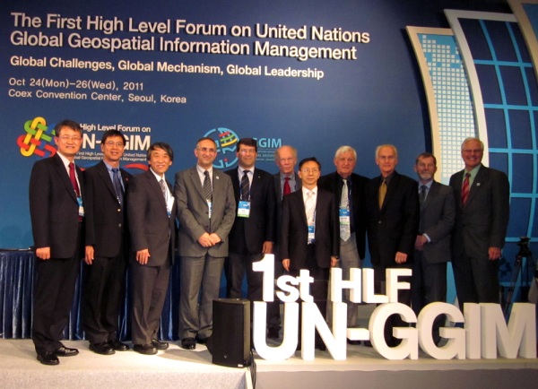
Mr
LEEM, Seong-An, President of National Geographic
Information Institute, Korea and Chair of the United Nations 1st
High Level Forum on Global Geospatial Information Management
[seventh from L-R] and Mr EOM, Kyoung-Soo, Chief of
Cartographic Section, United Nations [first from L-R] with members
of the Joint Board present at the Forum. The current Chair of the
Joint Board, Profession William Cartwright is third from R-L |
The Joint Board of Geospatial Information Societies had an ad hoc meeting
over two sessions on the sideline of the United Nations First High Level
Forum on Global Geospatial Information Management hosted by the Government
of the Republic of Korea in Seoul, held between 23rd and 27th October 2011.
The meeting was attended by eight of the ten member organizations of the
Joint Board chaired by Professor William Cartwright from the
International Cartographic Association. Others who attended were Mark
Cygan (IMTA), Professor Abbas Rajabifard (GSDI), Robert Ward
(IHO), Professor Fraser Taylor (ISCGM), Professor Ian Dowman
(ISPRS), Georg Gartner (ICA), Professor Lee (IGU) and TEO
CheeHai (FIG).
The Joint Board was heartened by the profile given by the United Nations
to international professional geospatial societies at this inaugural High
Level Forum and in particular noted that the Chair of the Joint Board,
Professor William Cartwright, gave the keynote presentation for Session #3
of the High Level Forum that had the theme “International Coordination and
Cooperation in Meeting Global Needs”. The presentation was a collaborative
effort of the members of the Joint Board and presented as a joint
presentation. The presentation was proceeded by a number of presentations by
panellist who are national delegates to the Forum, all stressing the
importance and necessity of international cooperation and collaboration to
meet global challenges. The Joint Board is held up as a good example.
At the end of the Forum and the first meeting of the United Nations
Committee of Experts, the Chair of the Joint Board, Professor William
Cartwright, was included as a member of the “extended” Bureau for the United
Nations Committee of Experts on Global Geospatial Information Management,
underlying the necessity for international professional geospatial societies
to work collaboratively and to have a collective voice within the United
Nations system. The Bureau has the Republic of Korea and the United Kingdom
as Co-chair and Chile as the Rapportuer. The “extended” Bureau will include
chairs from the United Nations regional cartographic structures and the
European Union.
The Joint Board resolved to have its next face-to-face meeting at the
XXII Congress of the International Society of Photogrammetry and Remote
Sensing in Melbourne, Australia (25th August – 1st September 2012) hosted by
ISPRS as well as convening a Joint Board session at the Congress. The Joint
Board also agreed to have another Ad hoc meeting on the sideline of the
second meeting of the United Nations Committee of Experts on Global
Geospatial Information Management in New York (13 – 15 August 2012).
The ten Members of the Joint Board of Geospatial Information Societies are:
- Global Spatial Data Infrastructure (GSDI) Association
- IEEE Geoscience and Remote Sensing Society (IEEE-GRSS)
- International Association of Geodesy (IAG)
- International Cartographic Association (ICA)
- International Federation of Surveyors (FIG)
- International Geographic Union (IGU)
- International Hydrographic Organization (IHO)
- International Map Trade Association (IMTA)
- International Society of Photogrammetry and Remote Sensing (ISPRS)
- International Steering Committee for Global Mapping (ISCGM)
CheeHai TEO
President
October 2011
11 November 2011
|


