News in 2018

|
References Frame in Practice Seminar - Operational Aspects of GNSS
CORS
18-20 September 2018, Suva, Fiji

The FIG Asia Pacific Capacity Development Network (AP CDN) convened
another seminar of the Reference Frame in Practice series in Suva, Fiji
18-20 September 2018. The event was a result of discussions held
at the FIG Congress in Istanbul (Turkey) at the AP CDN open meeting.
Since then development partners of the network namely, the Fijian
Government - Ministry of Lands and Mineral Resources, Pacific Geospatial
and Surveying Council (PGSC), the UN GGIM AP, FIG Commission 5, and the
Pacific Geospatial & Surveying Partnership Desk – Pacific Community,
prepared a technical program based on the needs of geospatial and
surveying professionals in the region.
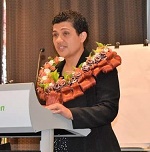
The seminar was officially opened by Fijian dignitaries –
- Reverend Raki Tigarea – Lecturer, Pacific
Theological College
- Dr. Andrew Jones – Director, Geoscience, Energy
& Maritime Division - Pacific Community
- Mr. Malakai Finau – Permanent Secretary,
Ministry of Lands and Mineral Resources
- Ms. Meizyanne Hicks – Vice Chair, PGSC
The theme and objectives of the seminar was to provide perspectives
and case studies on technical matters relating to the “Operational
Aspects of GNSS CORS” infrastructure. Presenters also delivered content
on the - “what, why and how” to build a sustainable and modernised
geodetic reference frame and datum; challenges faced in the Pacific in
relation to geospatial information management and data sharing; legal,
policy, and codes of practice (including standards); and the issues
pertaining to developing the capacity of surveyors in the discipline of
geodetic surveying.
There were 23 presentations and 2 exploratory “question and answer”
workshops over the 3 day event. The quality of all presentations
was of a high standard, which often stimulated involvement and
interaction amongst the seminar delegates. The registrations and
attendance to the event totalled just below 100, comprising of
surveyors, engineers, town planners, students and geospatial experts
from 14 different countries in the region. To view the technical
program and presentations please click
here.
At the conclusion of day 1 and the last day of the seminar
participants debated and workshopped the key takeaway messages,
opportunities, challenges and solutions to issues that evolved from the
seminar. These discussions led to how they could now move forward on the
main points raised during the exploratory workshops. It was decided that
a resolution, based on discussions and findings from the seminar,
outlining the challenges and related actions to resolve such challenges
be prepared. This resolution was circulated to reach a consensus view
from the participants. To review the seminar resolution please
click here.
On the final afternoon of the seminar all delegates were invited to
attend the commissioning of the Suva GNSS CORS located at the
Geoscience, Energy & Maritime - Pacific Community offices Mead Road,
Nabua. This GNSS CORS is the one of nine (9) new facilities that
will be constructed through the islands of Fiji, over the next few
years. The ceremony was attended by honorary guests Mr. Malakai
Finau (Permanent Secretary Lands and Mineral Resource), Mr
John Feakes
(Australian High Commissioner) and Dr Andrew Jones (Director Geoscience,
Energy & Maritime Division - Pacific Community).
The RFIP seminar was also evaluated by the delegates. Overall
the feedback was very positive as participants agreed the event was well
organised, had relevant and quality technical content, the atmosphere
and communication was friendly, very open and respectful, and also
mentioned similar events should be held in the future. FIG and
development partners recognised that responses of this nature are
attributed to the support and assistance provided. Consequently special
thanks are expressed to the staff from Fijian Government - Ministry of
Lands and Mineral Resources, staff from the Pacific Geospatial &
Surveying Partnership Desk – Pacific Community, to Leica Geosystems for
their financial support, and also local organisers Mr Andrick Lal and
Fiji Surveyor-General – Mr Asakaia Tabua for their time, efforts and
wonderful hospitality.
To view the Photo Gallery please click
here –
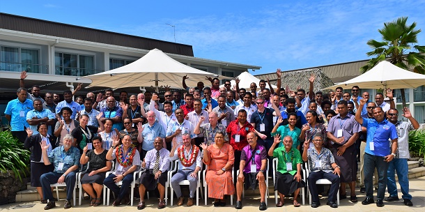
Group photo
Downloads:
Resolution “Operational Aspects of GNSS
CORS” - Reference Frame in Practice Seminar
The Seminar,
Reaffirmed the United Nations (UN) General Assembly
Resolution (A/RES/69/266) on the Global Geodetic Reference Frame (GGRF)
for Sustainable Development.
Reaffirmed the significance of Geodetic (and
geospatial) Infrastructure; Policies, Standards and Conventions;
Education, Training and Capacity building; Appropriate Governance; and
Outreach and Communication to achieving an accurate, sustainable and
accessible GGRF to support science and society.
Reaffirmed the GGRF underpins satellite positioning
technology, provides the framework for all geospatial activity and is a
key enabler of - spatial data integration and interoperability; disaster
risk mitigation, organisation and response; responsible land and water
administration, management and governance; and supports the monitoring
and measurement of the UN Sustainable Development Goals.
Recognised the important role of GNSS CORS
infrastructure to deliver a quality modernised GGRF and geodetic datum,
as well as providing quality geospatial and surveying services to
government, industry and the community.
Recognised that improved geospatial and geodetic
data sharing amongst Pacific Islands Countries and Territories (PICTs),
sectors of government, industry and the wider community will support -
datum determination and modernisation; unification of height systems;
measurement of Earth dynamics; integration and interoperability of
fundamental datasets; monitoring of sea level change, and the effects of
other natural phenomena such as tsunamis, earthquakes, storm and
flooding events, and volcanic activity; and
Noted further the additional benefits of sharing
geospatial and geodetic data include more effective, responsive and
accountable government, research outcomes, innovation, asset management,
service delivery, and also address the social and environmental
challenges and impacts associated with urbanisation, and disruptive
technologies.
Recognised the challenges of geospatial information
management, and geodetic surveying in the Pacific region, in particular
– the diversity of capability across the PICTs; establishing and
maintaining geospatial and geodetic infrastructure and systems with
often limited and finite resources both financial and human; data
sharing, availability and accessibility; treatment of data security,
privacy and sensitivity; financing and commercialisation of data and
infrastructure; and
Noted the need to modernise relevant legislation
(acts and regulations), policies, standards and practices in the context
of geospatial, surveying and geodetic infrastructure (i.e. GNSS CORS),
systems and data; and
Noted also other challenges such as accessing
reliable communications; the lack of awareness of the value and
importance of geospatial and geodetic information; gender diversity of
the industry; and the present limited availability of qualified young
geospatial and surveying professionals in the region.
Acknowledged the crucial the role and the function
of the Pacific Geospatial and Surveying Council (PGSC) as the principal
representative body of geospatial and surveying professionals in the
PICTS.
Acknowledged the ongoing administrative support and
technical operations of the Pacific Community - Geoscience, Energy &
Maritime Division and Pacific Geospatial & Surveying Partnership Desk.
Recommends that members, representatives and
supporters of the PGSC, as well as the geospatial and surveying
profession and community-
- Advocate, promote and communicate the profile, value,
importance, benefits (including economic and social) and
opportunities of geospatial and geodetic survey infrastructure and
information to government, decision makers, industry and the wider
community. Furthermore, that such activity should be through
various methods including digital and social media, active
participation at various related Pacific forums, and outreach
initiatives.
- Encourage and facilitate technical capability development
through training, workshops, and cooperation in GNSS CORS
densification; GNSS data processing; geodetic datum determination;
geodetic datum transformations; geospatial data management
integration, interoperability and systems; the use of geodetic
software; and geoid derivation and vertical reference frames /
datum.
- Adopt the globally accepted principles for geospatial and
geodetic data to ensure it is available to share, current,
authoritative, accessible, usable and interoperable.
- Encourage the development, and implementation of geospatial and
geodetic data strategies and policies, and ensure alignment with the
UN-GGIM Working Group on Legal and Policy Frameworks for Geospatial
Information Management.
- Promote and share geodetic data to support the International
Terrestrial Reference Frame (ITRF); regional geodetic programmes
such as the Asia-Pacific Regional Reference Frame (APREF) and the
Asia Pacific Regional Geodetic Project (APRGP); Pacific Sea Level
and Geodetic Monitoring Project; modernisation of national geodetic
datums in the Pacific; and the unification of height systems.
- Consider also sharing real-time GNSS observations to support
disaster and emergency management, and risk reduction including
tsunami and earthquake early warning systems.
- Encourage active involvement at the international, regional and
national levels with respect to geospatial and surveying standards
and practices and the related networks and frameworks.
- Engage in multilateral collaboration to review, evaluate and
modernise legal and relevant institutional arrangements pertaining
to administering geospatial and geodetic data and infrastructure.
This includes appraisal, and re-engineering or development of acts,
regulations, policies, standards and practices, and organisational
frameworks associated with geodetic datum; coordinates; GNSS CORS;
field and office practices with respect to data collection,
validation, analysis, processing and distribution; calibration and
testing; specifications and formats; geospatial and survey data
management and metadata etc.
- Engage with the relevant Academic community to participate in
appropriate geospatial or survey training or workshops and
operations.
- Engage with the relevant Commercial or Private Sector community
to participate in appropriate geospatial or survey training or
workshops and operations.
- Provide opportunities to develop and exchange technical
knowledge through internships and short term attachment programs for
geospatial and geodetic survey professionals.
- Encourage and support PGSC members and nominated
representatives, geospatial and geodetic surveying experts, and
decision makers to attend appropriate regional forums, capacity
development workshops and meetings.
- Build geospatial and geodetic surveying capability through
engagement with relevant international and regional experts.
- Encourage greater gender diversity and succession planning
through awareness campaigns, good news stories, mentoring,
professional development and regular engagement with educational
institutions.
- Prepare relevant national (or agency) strategic, implementation
and operation plans for relevant geospatial and geodetic survey
initiatives or activities, and ensure alignment with the PGSC
Strategy 2017-2027 – Positioning the Pacific Islands Countries and
Territories for the Future.
- Create a body of knowledge database or system, and contribute
information to allow sharing of experiences, documents,
presentations, papers, articles, business cases, plans etc.
regarding geospatial and surveying development in the Pacific.
- Work closely with the International Federation of Surveyors
(FIG), in particular the FIG Asia Pacific Capacity Development
Network (AP-CDN) and Commission 5; the UN-GGIM Asia Pacific WG1
Reference Frames; UN-GGIM Sub-Committee on Geodesy - Education
Training and Capacity Building; and other relevant organisations
such as Geoscience Australia, Land Information New Zealand,
National Geodetic Survey – NOAA, to invest in geodetic capability.
Rob Sarib
October 2018