|
NEWSLETTER NO. 3/03
JOINT COMMISSION WORKING GROUP ON
UNDER-REPRESENTED GROUPS IN SURVEYING
 Visit the Web site of the
FIG Working Group on Under-represented Groups in Surveying
Visit the Web site of the
FIG Working Group on Under-represented Groups in Surveying
This Newsletter in -pdf-format
Contents
Promoting geomatics in the UK by Rosie
Waddicor, Dr Jon Mills, Prof. David Parker, UK
Personalities: Bernadette M. Gitari, Kenya
Annual Report on Equal Opportunities for Women and
Men in the European Union 2002
Promoting geomatics in the UK
by Miss Rosie Waddicor, Dr Jon Mills, Professor David
Parker
School of Civil Engineering and Geosciences, University of Newcastle upon
Tyne
The Problem
 |
In the UK we have a problem which may unfortunately
be familiar to many of you: we do not have enough surveyors. Whilst
surveying companies continue to enjoy a steady flow of work they are
struggling to recruit well trained staff. The reasons behind this
shortfall of surveyors have been widely discussed: The poor perception
of surveying as a career and the relatively low salaries are just two
of the reasons put forward. In the UK one of the biggest challenges is
the profession’s recent identity crisis. The term “geomatics” is being
adopted by universities and an increasing number of companies to
describe the broad range of technologies we use yet few people have
heard the word and those that have do not link it to the science of
mapping, measurement and monitoring. |
The lack of young people entering the profession has hit surveying
educators hard: many college courses have disappeared whilst the handful
of universities offering degree-level training are finding themselves
under increasing pressure to boost their falling numbers. Two years ago,
Professor David Parker and Dr Jon Mills from the University
of Newcastle decided that something must be done to reverse the trend.
The Solution
By focussing on the fact that so few school leavers are familiar with
geomatics as a career, the solution was a simple one: get geomatics into
schools. This idea was the start of a national project, bringing together
people from all areas of the profession in a concerted effort to raise the
profile of geomatics. The project adopted the name “Geomatics.org.uk”,
taken from the Royal Institution of Chartered Surveyors’ (RICS) website
which had been set up a few years previously.
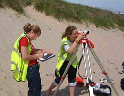 |
Figure 2: A day at the beach for Gosforth
High School pupils: this field trip was a collaboration between the
maths and geography departments. Students visited Newton-by-the-Sea to
measure beach profiles using the Geomatics.org.uk levels. Prior to the
trip, maths teacher Tim Johnson gave lessons on the trigonometry of
surveying. |
As geomatics is not a subject you’re likely to find in school text
books, it was necessary to find the links to existing subjects and develop
them. You can find the fundamentals of geomatics in mathematics, physics,
geography and computing. The next step was to help teachers and students
to realise that through these subjects, they already know quite a lot
about geomatics! For example, a maths lesson in trigonometry is an
introduction to the basics of surveying whilst the theory of GPS has its
roots in classroom physics. Important too is the cross-curricular nature
of geomatics. Teachers are encouraged to work across the boundaries of
subjects so a geography field trip to examine sand dunes can draw on
mathematics to assist with height measurements of the beach.
It’s all very well pointing out these links but in order for teachers
to actually bring geomatics into the classroom it was necessary to provide
them with the tools for the job. Most schools cannot afford to buy even
the most basic surveying equipment. To remedy this Geomatics.org.uk
purchased 14 engineer’s levels (with tripods and staffs) and handheld GPS
receivers. These kits are loaned out to schools for practical work and
field trips; furthermore these loans are free and supported by a wealth of
instructions, ideas and lesson plans, all available on the website.
It was not enough to have these resources available, we had to go out
and tell teachers and students about geomatics. To that end we’ve toured
the country attending conferences and exhibitions (the largest being a
month-long, 4 city tour with the BBC’s Tomorrows World!). We’ve run
teacher training days and student taster courses and written many articles
for a variety of publications. In fact we’ve been so busy it’s hard to
list everything!
Funding
By now I’m sure you’re wondering where the funding for such a project
has come from. We were awarded a “Promoting Public Awareness” grant by The
Engineering and Physical Sciences Research Council (EPSRC) which allowed
us to purchase the equipment and attend many of the events, as well as the
employment of a full time member of staff, Rosie Waddicor, to
coordinate all of our activities.
Initial support, however, came from the geomatics profession itself. As
mentioned above the RICS were quick to recognise the importance of this
project. The International Marine Contractors Association (IMCA), the
Institution of Civil Engineering Surveyors (ICES), The Survey Association
(TSA) and the Ordnance Survey were all keen to get involved. It is
important to note too that the survey industry recognises the necessity of
promotion to young people as evidenced by support received from many
companies. Finally the educators of surveyors - the universities, are
collaborating through Geomatics.org.uk. These universities, although
competing for the same students, realise that working together is far more
effective than pushing on alone.
This broad range of organisations, companies and institutions
represents the entire geomatics spectrum: from land surveying to
hydrographic surveying, photogrammetry, GIS and remote sensing. By working
together, pooling resources and sharing ideas we can achieve a lot more
than individuals working in different directions.
Finding out more
If you’re interested to find out more about the project I suggest you
visit our website
http://www.geomatics.org.uk. As well as the resources for teachers we
have a Members Area especially for those in the profession. We’re always
looking for fresh material for the website so if you have a short article
or a few images from an interesting project you’ve worked on, we would
love to include it.
You can also contact geomatics.org.uk directly using the following
details: Miss Rosie Waddicor, Email:
rosemary.waddicor@ncl.ac.uk
Acknowledgements
The work of geomatics.org.uk is funded by an EPSRC Public Awareness
research grant (number GR/R78930/01) and the RICS, ICES, TSA, IMCA,
Ordnance Survey and the Hydrographic Society (Scotland). Thanks also to
our industrial sponsors including: Fugro UDI, Subsea 7, Halcrow Geomatics
and PCA Geomatics.
Example from the Teachers Area
http://www.geomatics.org.uk
Surveying | GPS Orienteering
One of the easiest activities you can do with a GPS receiver is to
set up your own orienteering course!
This is a quick activity to organise and set up. It is a good way of
introducing students to the GPS receivers and works with any age group
(the youngest group so far were just 5 and 6 years old!).
You will need:
- a set of receivers (this exercise works well with groups of two or
three children to each receiver)
- flags or markers
- an open space (a playing field etc - anywhere as long as there is a
good view of the sky)
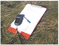
- clipboards, pencils
Setting up:
The main task is to set up your course. Go out with a single receiver
and record waypoints (stored coordinates on the receiver) at your chosen
points. Avoid areas with overhanging trees or very close to buildings
because these things will limit the receiver's view of the sky. Remember
too that the accuracy is 5m at best (although it can be 10 - 15m on a bad
day) so leave plenty of space between points. The number of waypoints you
record will depend on how long you want the exercise to take - between 5
and 10 points is about right for a lesson lasting 1 hour.
Once you have collected the waypoints you need to transfer them to the
other receivers. There are two ways of doing this: manually or using
software.
To transfer the points manually:
- Note down the list of waypoints and their names.
- Hold down the click stick to bring up the "Mark Waypoint" page (a
little guy holding a flag!). Now use the click stick to highlight the
Location field and enter the new coordinates using the numerical
keyboard.
- Select okay when you have finished.
- You can also change the name and symbol of the waypoint on this page
(highlight the appropriate field and change what you want)
To transfer the points using software:
- You will need either: Map Source (available to buy from Garmin, see
Links page) or EasyGPS (available as a free download, see links page
also).
- Connect the receiver to your PC using the download cable (available
from us as a loan, make sure you ask if you think you might want one!).
- Follow the on-screen instructions for uploading (getting information
off the receiver) and downloading (getting information onto the
receiver).
- You will have to upload the waypoints from your first receiver (this
is your chance to tidy them up too: delete any you don't want and make
sure all the names are right) and then download them to all of the other
receivers.
Once you have the waypoints on the receivers you need to set out
your flags.
Flags can be real orienteering flags (you can buy small, paper ones
quite cheaply), laminated paper squares on pegs or whatever you prefer.
You will need to write words or letters on the flags.
Think of a relevant word or phrase and write either individual letters
or whole words on the flags. The order doesn't matter because the final
part of the exercise for the students is to rearrange the words or letters
to get the answer.
You might like to create some extra, dummy flags with incorrect words
or letters on them - if these are scattered across the field among the
real flags, it prevents students simply walking to the flags and cheating!
Running the exercise:
- Divide the group into pairs or threes and give each group a
receiver. If this is the first time the group has used the receivers
remember to tell them the basic rules of use: always keep the receiver
around your neck, keep one eye on where you are going at all times and
don't run!
- Get everyone's receiver recording a position - this shouldn't take
too long and it gives you chance to explain what is happening on the
screen. When you get the message "Ready to navigate" and an accuracy,
that means you're ready.
- There are two ways of navigating to the correct flags - choose which
you think is most appropriate for your students. The first way is just
using the map page, the second way (slightly more complex) is using the
navigation page.
Two ways of navigating to the waypoints:
Using the map page:
- This is perhaps the simplest way of navigating to the waypoints.
- Look at the map page (the one after the satellite page) - you should
see all of the waypoints you stored and their names.
- If you stay on the map page and walk around you will see that the
black triangle in the centre represents the receiver and that you
actually track around the map.
- Walk to each point on the map in turn using the map as a guide.
Using the navigation page:
- Press the Find button (has a magnifying glass below it) and it will
bring up the Find menu
- Select Find Waypoints and then select Nearest
- This will bring up a list of all the waypoints stored in the
receiver (it makes it easier at this stage if all surplus points have
previously been deleted).
- Click on a waypoint from the list (any one, it doesn't matter which)
and this will bring the Flag page.
- At the bottom of this page click Goto (should already be
highlighted) and this will bring up the navigation page.
- Follow the arrow of the compass and use the distance at the top of
the page to navigate to the chosen waypoint.
- Repeat this process until all points have been visited.
Once the students find a flag, they need to note down the word or
letter on it.
Remember that the GPS is only accurate to 5m at best so once they get
close to the point they are looking for they may need to scout around a
bit to find it!
The exercise is complete when the students have found all of the flags
and rearranged the letters or words to get the phrase or word you chose.
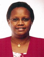 |
Bernadette M. Gitari,
is a professional Valuation and Estate Management Surveyor licensed to
practice in Kenya, East Africa and has 23 years experience in this
field. Having grown up and attended rural schools, Bernadette had no
idea what Land Economics entailed. However, when she joined high school
for her A-Levels, Economics was one of her subjects and thereby she
developed an interest in Economics. The need to specialize in Economics
led her to choose Land Economics as a professional course as opposed to
general Bachelor of Arts degree in Economics. |
Bernadette began her career immediately after
graduating from University of Nairobi with BA in Land Economics by joining
Lloyd Masika Limited, one of the leading Valuation and Estate Management
companies in Kenya. During this period the valuation and estate management
field, in the private sector, was male dominated. Most women opted to join
the Government mainly because the government offered job security and the
job is also not challenging. Bernadette chose to take the challenge and
opted to join the private sector and in particular aimed at becoming a
Valuation and Estate Management Surveyor. This was a great challenge for
not only is one supposed to perform the work but also it entails dealing
with all categories of clients most of whom are knowledgeable.
In 1983/84, she was involved in rating objections in
a Valuation Court challenging the valuation figures prepared by the
municipal council for rating purposes. She was able to obtain reductions
in the valuation figures of nearly 60% of all the valuations challenged
through the valuation court.
Throughout her career Bernadette has carried out
challenging valuation assignments of all categories of properties, notably
large agricultural coffee, horticultural and tea estates, large industrial
complexes such as cement manufacturing factories, high-rise residential
and ultra modern commercial buildings in Nairobi and other major towns in
Kenya, just to mention a few. She has also handled all categories of
clients ranging from individuals with a one off property to International
companies with large property portfolios. Bernadette has also been
involved in the training of assistant valuers preparing to sit for the
Institution of Surveyors of Kenya Diploma examinations.
As a result of her hard work and dedication to Lloyd
Masika Limited, she became a shareholder of the company in 1986 and
subsequently a Director in charge of the valuation department in 1989, a
position she held up to 1996. Currently Bernadette is involved in office
administration of the firm as well as carrying out feasibility studies,
development appraisals, and research in various aspects of the property
market.
Bernadette has a great interest in computerization of
valuation and estate management operations and has been involved in the
development of a management and accounting software for the management,
accounts and agency departments. At the moment she is working on a
project, with other consultants on how to computerize the Ministry of
Lands and Settlement in Kenya. Her main involvement in the project is on
land administration and registration.
The same zeal to excel and take challenges in the
valuation profession prompted Bernadette to pursue further studies in
valuation and estate management. In January 2000, she enrolled for a
graduate program for an MA degree on a part-time basis. She completed her
graduate program in a record period of 18 months and was awarded an MA in
Valuation and Property Management in November 2001. In July 2001,
Bernadette enrolled to study, by correspondence, for a Diploma in
Surveying at the College of Estate Management in UK as a requirement for
acceptance as a Member of the Royal Institution of Chartered Surveyors (RICS).
She completed the course in December 2002. Bernadette has submitted the
papers for the final assessment and is hopeful that she will be accepted
as a member by July 2003.
Bernadette learnt about FIG in the year 2001 and was
able to attend the Conference in Washington DC in April 2002.She
participated in the joint commissions on Gender and Underrepresented
Groups. In her efforts to encourage more women into the valuation
profession and to place the Kenyan women in Valuation and Estate
Management on the Globe, she was elected to the local professional body,
The Institution of Surveyors of Kenya (ISK) as an Assistant Secretary in
charge of examinations and training in April, 2003.
One of her main agenda as a member of the Institution
of Surveyors of Kenya Council is to set up a body within the Institution
that would cater for women needs in terms of career development, for women
in surveying, sensitizing those who would wish to join surveying
profession in Kenya, the need to network with other women in the Surveying
Profession from other countries in the world as well as attending
International Meetings and forums on Surveying.
Bernadette is a committed Catholic, is a Member of
the Board of Thomas Barnados Children Home and Jonathan Gloag Academy.
Bernadette is a single mother of a teenage son aged 20 years.
Annual Report on Equal Opportunities
for Women and Men in the European Union 2002
The Commission of the European Communities adopted
the 7th annual report on equal opportunities on 5 March, 2003.
Executive Summary
This Annual Report, the seventh on Equal
Opportunities for Women and Men in the European Union, presents an
overview of the main developments and achievements at Member State and
European level in 2002 in the area of gender equality.
2002 was a momentous year, marking a historic
milestone in the enlargement process with the conclusion of accession
negotiations with Cyprus, the Czech Republic, Estonia, Hungary, Latvia,
Lithuania, Malta, Poland, the Slovak Republic and Slovenia. The Union now
looks forward to welcoming these States as members from 1 May 2004. This
intervening period provides the opportunity to reinforce monitoring and
co-operation support for these countries in their final stages of
preparation for full membership. In this context, the Action Programme for
gender equality was opened to candidate countries during 2002.
2002 also heralded the start of the work of the
Convention on the Future of Europe. The lack of women's representation
within the Convention has been criticised and, to counterbalance this
deficit, a strengthened gender mainstreaming approach has been advocated.
In responding to the many challenges facing the European Union, it is
clear that any future Constitutional Treaty must reflect the aspirations
of women and men in an enlarged Europe and confirm the established
principle of equal treatment between women and men. In order to achieve a
gender equal society, the Union must continue working to eliminate
inequalities and promote equality between men and women in all its
policies and actions (gender mainstreaming).
The Framework Strategy on Equal Opportunities for
Women and Men continued to provide a structure for gender mainstreaming of
all policy areas, and 2002 saw, for example, the evaluation of the
European Employment Strategy, including the impact of gender
mainstreaming, and an analysis of Gender in the Structural Funds.
Important progress was made in raising awareness and exchange of good
practice in the Social Inclusion process and in the Pension Report.
The successful amendment of the Equal Treatment
Directive thanks to strong collaboration with the Council and European
Parliament in the co-decision process, moved the agenda of equality firmly
forward in the area of employment. Attention also focused on domestic
violence against women, including the adoption of indicators, and efforts
were stepped up to prevent and eliminate this unacceptable practice.
Gender equality is a human right for all and visible
international solidarity and support for women who are denied this right
is essential. Some important steps were taken in 2002, but much remains to
be done and this therefore will continue to be a crucial area for efforts
in the future.
For comprehensive statistical data, an extensive
statistical portrait of 'The life of women and men in Europe' was
published in 2002 by Eurostat (ISBN 92-894-3568-2).
The whole report (KOM(2003) 98 final: 25 pages) is
available on the following page:
http://europa.eu.int/comm/employment_social/news/2003/mar/com0398_en.pdf
|
Editor: Chair of the Joint Commission Working Group
on Under-represented Groups in Surveying
Ms. Gabriele Dasse,
Kleinfeld 22 a, D-21149
Hamburg, Germany
E-mail: g.dasse@gmx.de
3/03, month of issue:
July
© Copyright 2003 Gabriele Dasse.
Permission is granted to photocopy in limited quantity for educational
purposes.
Other requests to photocopy or otherwise reproduce material
in this newsletter should be addressed to the Editor.
|
|