FIG Task Force on Spatially Enabled Societies

|
Background
The Council has decided in February 2009 to establish a
new short term Task Force with the aim to explore the issue of Spatially
Enabled Societies (SES) from a cadastral and surveyor’s point of view.
Dr. Daniel Steudler from Switzerland has been appointed
to chair this task force. The results of the Task Force will be
published in a report that will be launched at the FIG Congress 2010.
Project Idea
It is proposed to establish a short term Task Force (TF) with the aim
to explore the issue of Spatially Enabled Societies (SES) from a
cadastral and surveyor’s point of view. The purpose is to identify the
role of the profession, how it can provide for a spatially enabled
society and to make recommendations. The TF should attempt to take
different regional perceptions on board and to reflect them. The context
would have to take different economic and social situations into
account, developed as well as developing countries.
The expected result of this task force is to develop a comprehensive
FIG position paper on SES (about 20 pages), and 4-5 regional reflections
of 2-4 pages each. This will be launched as a FIG publication at the
Congress in Sydney 2010.
Scope
The 13th PCGIAP meeting in 2007 concluded with the statement that “A
spatially enabled government is one that has ready access to the spatial
or geographic or location based information and associated technologies
that it requires and is applying these productively to government
decision making, including developing policy and supporting its own
business processes”. In analogy, societies can be considered as
spatially enabled “where location and spatial information are regarded
as common goods made available to citizens and businesses to encourage
creativity and product development” and so informed can participate in
the decision-making and governance process.
The Bathurst Declaration established the dependency between
sustainable development and land administration and made the clear
statement that "sustainable development needs sound land
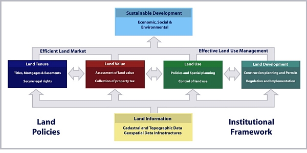
administration". Often the term "Land Management" is being used in this
context as illustrated in the following figure.

The Land Management Paradigm
EuroGeographics, in their vision document “Cadastre and Land
Registration in Europe in 2012”, identify the trends and developments in
two complementing directions. Accordingly, the field of C&LR is to
provide security of ownership – through an established and reliable
cadastral system – and based on the same information to provide geodata
and services to the market. The contribution and role of the cadastre in
this structure is to collect, maintain and update authentic and official
data in reliable registers. This concerns mainly private- and public-law
rights and restrictions, as well as official and basic geodata serving
multiple public purposes, such as geo-referenced addresses. In doing so,
the cadastre can contribute to sustainable development through multiple
services based on reliable information.
It is important for the surveying profession and for the cadastral
institutions to recognize their roles in this context. Only with this
awareness, the profession can develop itself, foresee opportunities and
prepare for the future.
Proposed Time Schedule
| March
2009 |
Informal discussion of next steps to be
taken and to agree on potential TF members (at the FIG/WB
conference in Washington DC) |
| May
2009 |
Meeting of TF, preparation of position
paper and how to get regional input (at FIG Working Week in
Eilat, Israel) |
|
June-August 2009 |
Regional input (through regional
contributors) |
|
July-September 2009 |
Feedback of regional contributors to be
circulated among TF members |
|
October 2009 |
Position paper finalized by TF members |
|
December 2009 |
Final text by regional
contributors |
|
January 2010 |
Editing and
finalizing of extended paper |
| April
2010 |
Launching of publication at the FIG
Congress in Sydney |


