The Achievements of the Vietnam-Sweden Co-operation Programme on Land Administration SWEDEN - VIETNAM COOPERATION ON LAND ADMINISTRATION REFORM IN VIETNAMProf. Dr. Sc. DANG Hung Vo, Vietnam and Gösta PALMKVIST, SwedenKey words: SUMMARYThis paper has the purpose to present briefly in the FIG meeting the current implementation of the land administration system of Vietnam and the successful cooperation between Vietnam and Sweden in this area. The authors focus firstly on the history, current status of land issues and land administration system building. After that, the strategic developments in the future planning are discussed. The authors then present the Vietnam-Sweden Cooperation Programme on Land Administration Reform (CPLAR) with a description of its contents and results. CPLAR plays the important role in the process of studying modern methodology, technology solutions, foreign experiences learning and human resources development. CPLAR also considers analysis of socio-economic, environmental and gender issues in the land administration field. The CPLAR's activities have assisted in development of several useful technical solutions for the General Department of Land Administration (GDLA). 1. BRIEF INTRODUCTION ON THE HISTORY OF LAND MANAGEMENT IN VIETNAMThe first cadastral system in Vietnam was established by the Le dynasty in 1490. It is a DEED system in service for the nationwide land administration focusing on the utmost collection of agricultural tax. Meanwhile Hong Duc Law, the first Vietnamese law, was promulgated, of which 60 articles were about the land. The second cadastral system established in Vietnam took 31 years between 1805 and 1836 by the Nguyen dynasty. It is a DEED system also containing 10,044 volumes of cadastral books that covered 18 thousand communes across the country. Meanwhile Gia Long Law, the second Vietnamese law, was promulgated, of which 14 articles were to regulate the civil and administrative relation on housing, land and rice tax. On their first arrival to Vietnam in the mid-19th century, the French, without any delay, started making cadastral maps with coordinates and setting up new cadastral books so as to strengthen their agricultural tax collection in rural areas and further control markets of real property in urban areas. It is the third cadastral system established in Vietnam. The DEED system was applied for rural land whereas the TITLE system was applied for urban land. Soon after the Democratic Republic of Vietnam (former name of the Socialist Republic of Vietnam) was founded, Vietnam suffered from wars for 30 years between 1945 and 1975. Land administration was ignored in the following 1975 - 1986 period because of the centralised planning economy model. In the first half of 80's of the last century, Vietnam's economy had very low productivity in agriculture, which caused lack of food for social needs. The economic solution to this problem was based on the allocation of agriculture land to individuals and households. This policy has brought Vietnam into the position as one of the three leading countries of rice export in the world. In 1986 the State of Vietnam decided to innovate its economic system under the market economy model managed by the State. Since then, land administration has been regarded significant to secure political stability, social justice and economic development. The Vietnamese land law was first approved by the National Assembly in 1988. After having been carried out for 5 years, some articles proved to be not encouraging enough for development of the market economy. A revised land law was therefore promulgated and approved by the National Assembly in 1993, called the 1993 Land Law. In early 1994 Vietnam Government decided to establish the General Department of Land Administration (GDLA) by merging and reorganizing two state bodies; General Department of Land Management and National Department of Surveying and Mapping. The land administration system of Vietnam is a nationwide four-level system including the GDLA at the central level belonging to the Government, Department of Land Administration (DLA) at provincial level belonging to People's Committee of Province, Bureau of Land Administration (BLA) at district level belonging to People's Committee of District, and one/two Land Officers in each commune. The land administration bodies are responsible for the land management and survey - mapping. The tasks are as follows:
Based on the technical assistance founded by UNDP and AUSAID, during 1991 - 1994 Vietnam land administration carried out the Feasibility Study (F/S) on establishment of a modern land management system for Vietnam. The F/S results have supplied reasonable justifications for the long-term planning on development strategies. The World Bank, in the period 1994 - 1997, has had several discussions with GDLA on utilization of WB soft loans for the total implementation of modern land management in Vietnam. The proposed budget in this F/S was USD 360 million. After consideration Vietnam's Government decided to use the state budget for implementation of the land administration system. In general, the construction of a modern land administration system
in Vietnam would be called the land administration reform. A total
solution of this process should be concerned in the legal,
technological, economical, and social aspects. In 1995, the Sweden
International Development Agency (SIDA) intended to support GDLA with
a technical assistance project for the methodology and technology
study. Two years later, Sweden and Vietnam governments signed the
specific agreement on the programme named "Vietnam-Sweden
Cooperation Programme on Land Administration Reform - CPLAR" for
10 years. CPLAR is being carried out in 2 phases in which the first
phase is from 1997 to 2001 and the second phase from 2002 to 2007. The
first phase will be completed at the end of 2001 with the budget SEK
88 million, in which SEK 65 million from Swedish contribution and SEK
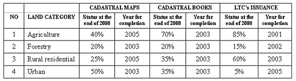
23 million from Vietnamese contribution in kind. 2. CONTENTS OF LAND ADMINISTRATION REFORM IN VIETNAMIssues related to renovation of the land administration system in Vietnam are introduced in this part. The main contents of the land administration reform are as follows: 1. Complete the land legislation and land policy system based on political stability, social justice and economic development; effectively strengthen to the land inspection system; well settle land disputes: According to Vietnam Constitution land is the property of the entire people, which is allocated or leased by the State to organizations, households or individuals for long-term use. Depending on their status, land users are fully or partly granted the rights of land exchange, transfer, inheritance, mortgage, lease and investment into joint-venture. Rural land is used for cultivation, development of the rural socio-economy and food security, so that the necessary land for afforestation must be secured and the ecological environment protected. Besides, the State appropriately provides land for the national industrialization and modernization, including the construction of infrastructure, centralized industrial zones and urbanization in dealing with resettlement. The first land law was approved by the National Assembly in 1988, and after that the land law has been renewed or revised every 5 years. The second land law was promulgated in 1993, the revised land law in 1998, and the third land law may be created in 2002. During the period 2003 - 2008 GDLA will have full conditions for preparation of the Land Code to submit to National Assembly for approval. 2. Accomplish the establishment of initial cadasral documents consisting of land allocation, land registration, cadastral maps, cadastral books, and land tenure certificates (LTC) for 19 million ha of currently used land; facilitate the administrative procedures of land user rights performance and cadastral documents update based on organization of land title office: Initiation of cadastral documents in Vietnam that started in 1990 was subject to the title system. LTCs were issued to land users on the basis of unified system of cadastral maps and cadastral books. There are currently around 13 million land users, of whom 10.5 million in rural areas and 2.5 million in urban areas, for about 100 million land parcels in Vietnam. LTCs will be issued until the year 2005, by then the land amalgamation will reduce the number of parcels and the LTC will step-by-step be replaced by a parcel based system. It is impossible to complete all the new cadastral maps by the year 2000 so all the old ones would remain suitable for the present situation. Initial registration of land for 13 million land users is considered a huge task to tackle. The current situation and schedule for completion of the initial cadastral documents are presented in the following table:
During the time for implementetion of the initial cadastral documents, GDLA is studying the land title office system which will simplify administrative procedures in the land administration system. 3. Carry out land investigation, land survey, land statistics, land use mapping to form the basic document for short-term and long-term land use planning: Pursuant to the Vietnamese land law, the National Assembly approves the long-term land use planning once it is suitable for the nationwide planning of socio-economic development. The Government will annually approve land use plans submitted by provinces or by economic sectors. In current time, the land administration organizations do not yet firmly grasp all occurrences in the land use process. From that reason all land use planning does not get legal effectiveness in the administrative system, and does not support implementation of socio-economic development planning. GDLA has now to renovate the procedures of land use planning on the basis of methodology studies and practical testing. A reasonable planning of land use should have the systematic characteristics guaranteeing the unification of economical sectors planning with administrative localities planning. The long term land use planning should be in conformity with the annual land use plan, which constructs favorable conditions to secure the land allocation, land lease and land recovery. The administrative procedures of managerial system must be streamlined over the transferring process of land use. 4. Establish the system for land classification, land assessment, and land valuation to upgrade the land taxation system and to form the legal frame for real estate market: The land valuation is a new task of land administration system in Vietnam which is the economic tool playing an important role in land management. The land valuation system gradually supports the real estate market, correctly defines land tax, land compensation, land mortgage, from that it is possible to speed up the infrastructure construction of industrialization and increase the state revenue made from land resources. GDLA is concentrated now on the studies on land valuation methodology and experiences. Some methods of valuation have been tested already for urban and industrial land. The legal frame and organizational system of land valuation have also been prepared and will be submitted to Government in the near future. 5. Modernize gradually the land administration system oriented to information technology based on establishment of the National Land Information System (NLIS): From 1997 all the cadastral documents, including cadastral maps, are made by digital technology. That means up to now about 60% of new cadastral documents were captured and archived already in computers (40% of them are still on paper). In present time GDLA is focused on establishment of the National Land Information System (NLIS). It is most important technical infrastructure for modernization of the land administration system to facilitate and also to simplify all the administrative procedures. Besides, NLIS has the function for supplying the land information such as land statistics, current land use maps, land use planning, etc. and the information related to the natural, economic, social and legal conditions on each land parcel to meet the civil needs. In 1999 GDLA submitted the Feasibility Study on construction of the National Geo-database and Land-database, which was approved by the IT State Committee. This Database is organized as a distributed database system, in which each provincial DLA has an own land-database including all the cadastral documents of this province and GDLA has two component database, first one is the Geographic Database and second one is the Macro Land Database. All the component databases are connected by wide area network (WAN). From 1999 to 2001 GDLA manages several projects to prepare the nationwide implementation of the National Geo/Land Database:
According to the GDLA's planning the National Geo-database, National Land-database, and NLIS will be completed in 2010. 3. VIETNAM-SWEDEN COOPERATION PROGRAMME ON LAND ADMINISTRATION REFORM IN VIETNAM - CPLARIn 1997 the Sweden and Vietnam Governments signed the specific agreement on setting up the Vietnam-Sweden Cooperation Programme on Land Administration Reform in Vietnam (CPLAR) for 10 years, in which the first phase is implemented in the period 1997 - 2001 with SEK 65 million from Swedish contribution in cash and SEK 23 million from Vietnamese contribution in kind. The second phase will be considered by the two sides later in 2001. The first phase of CPLAR includes 6 projects: project 1 - Land Legislation, project 2 - Cadastral Mapping, project 3 - Land Use Mapping & Planning, project 4 has 2 components: project 4.1 - Land Valuation and project 4.2 - Land Registration, project 5 - Land Information System, project 6 - Programme Management. The contents and results of each project will be described as follows: 1. Project 1 - Land Legislation: The main objectives are: (1) - methodology study on land legislation system to propose revisions to the current land law of Vietnam, (2) - study on formulation of the legal frame for the real estate market in Vietnam, (3) - study on proposals of land policies for the ethnic minorities in Vietnam. The results of this project in 1997 have played the important roles in preparation of the revised land law, which was promulgated in 1998 by the National Assembly. During the period 1998 - 2000, this project has been focused on the legal frame for real estate market and the land policies for ethnic minorities. 2. Project 2 - Cadastral mapping: Cadastral map system of Vietnam has been defined by GDLA as follows:
The main objectives of the project 2 are: (1) - pilot study on cadastral survey methods by total station, RTK GPS, and orthophoto mapping, (2) - proposal on digital cadastral map standards, (3) - strengthening technological capacities for survey and mapping works at provincial level. Project 2 has concl;uded on selection of suitable cadastral survey methods for each category of land. Digital cadastral map standards have been proposed to GDLA for approval. 3. Project 3 - Land use mapping and land use planning: It is extremely difficult for the land administration sector, relevant economic sectors as well as local authorities to set up long term land use planning and annual land use plans in the condition that initial land records have not yet been established. However, a nationwide long term land use planning up to 2010 has been set up by GDLA, and already been submitted to the Government. Annual land use plans for every province and economic sector are approved by the Government. However, the approved land use planning as well as annual land use plans are not fully implemented in the social life. The main objectives of project 3 are: (1) - application of digital technology for land use mapping, (2) - methodology study on land use planning in which the suitability between economical sectors and localities must be considered, (3) - proposal on a new technical procedure of land use planning. Up to 2000, project 3 has carried out a pilot study on the new technical procedures of land use planning at provincial, district and communal levels in Ha Nam province. Land use mapping by digital technology has been tested with utilization of the aerial-satellite images and current cadastral maps. 4. Project 4.1: Land valuation Land valuation is the new concept in the land administration system of Vietnam. Up to now Vietnam has not any system of valuation offices, then land price is defined on the basis of the government land price frame. The difference between the government price and the market price is quite big. The main objectives of project 4.1 are: (1) - methodology study on land valuation, (2) - testing and choosing suitable methods on land valuation in Vietnam, (3) - proposal on establishment of the land valuation office system. Project 4.1 has considered several methods for land valuation, after that some of them have been applied in pilot study area. The methods proposed by the project were accepted for use in several provinces. Project 4.1 has also proposed a plan on organization of the land valuation offices in Vietnam. This plan will be the basic document for submission to the Government for consideration. 5. Project 4.2 - Land registration: Land registration and LTC's issuance are the main tasks in the period of the initial cadastral documents implementation. Since 1988, this work started with the unified technical instructions. Up to now the land registration and LTC's issuance are implemented rather smoothly, but there is a problem with the complicated administrative procedures. The main objective of this project is to simplify the present administrative procedures oriented to organizing a land title offices network. The project has made the methodology studies and practical tests on land title office system in some provinces. 6. Project 5: Land information system Land information system is the goal of the modernization process of land administration. Project 5 has the objectives: (1) - study on the public demands on the land information system, (2) - Land-database and computer network design, (3) - tests on land data processing softwares and data management softwares. Project 5 has carried out several pilot studies on formulation of the rational LIS model for provincial level. These pilot studies are concentrated on the following topics:
The provincial LIS model proposed by Project 5 has been approved by GDLA for application throughout the land administration area. 7. Project 6: Programme management The main task of Project 6 is coordination of activities for the whole programme, including planning and financial management, annual reporting to SIDA and GDLA. Besides, Project 6 has also some important specific tasks as follows:
The consultancy organization for CPLAR has been selected as Swedesurvey, which was winner in the international bid for implementation. The excellent cooperation between SIDA and GDLA, Swedesurvey and Vietnamese partners are the most important part forming the CPLAR's success. In 2001 SIDA and GDLA will start preparation of the second phase of CPLAR for the period 2002 - 2007. 4. CONCLUSIONSDevelopment of land administration in Vietnam is regarded by Government as of high priority in the process of industrialization and modernization of the country. The target of Vietnam is to become an industrialized country before 2020. Turning an agricultural developing country into an industrialized one is an extremely heavy task. Development of the 4 input power resources of labour, land, finance and technology is particularly significant to the national socio-economic development. In the meantime, issues of land related to social justice, food security, environmental protection and political stability must be well solved. The completion and modernization of the land administration system of Vietnam must be concentrated in the next 10 years. The CPLAR's activities are giving the good methodologies, technology solutions, and management experiences to the land administration of Vietnam at central and local levels. The Vietnam - Sweden cooperation in the land administration area brings the successful results to assist GDLA in the development. CONTACTDr. Sc. DANG Hung Vo Gösta Palmkvist 14 April 2001 This page is maintained by the FIG Office. Last revised on 15-03-16. |