COMMISSION 3 IN PROGRESSJes RYTTERSGAARD, DenmarkKey words: Commission 3, Information Management, NSDI, Internet, e-commerce. INTRODUCTION TO SPATIAL INFORMATION MANAGEMENTIn a few years no one will think of spatial data as something special. Spatial data will be integrated in all kinds of information systems. Sometimes they will be visible. In other cases they will be invisible, but indispensable because they are the underlying basis in the different information systems. In time with integration of spatial information in the various information systems, there will be a strong need for people who can manage the technical and organisational aspects of combining data and in turning raw data into understandable information. Aspects comprising disciplines as common standards, common data models, models for spatial information infrastructures etc. With other words, people who are skilled in Spatial Information Management. PRESENTATION OF COMMISSION 3In 1998 the field of responsibility for Commission 3 was changed from GIS/LIS to Spatial Information Management. To day the term Spatial Information Management (or Geographic Information Management) has been adopted by several involved in the traditional GIS businesses. The new field of responsibility found expression in the following "Terms of reference":
Against a background of this change in responsibility the Commission formulated the following mission statement:
The three working groups are:
Commission 3 works through the Working Groups and by bringing people together. At working weeks and seminars we offer people from different countries the possibility:
Like the other 9 technical commissions in the FIG structure Commission 3 is responsible for seminar sessions during the annual FIG working week. In addition Commission 3 arranges a seminar including an annual meeting every year. Till now we have had annual meetings in Budapest, Hungary in 1999 with 70 participants and in Athens, Greece in 2000 with almost 100 participants. The criterion of success has been fulfilled. From the 2-5 October this year we will have a conference in Nairobi, Kenya with the title "Spatial Information for Sustainable Development". The expected number of participants will be near 250. Our colleagues from the Institution of Surveyors Kenya have arranged the conference in co-operation with UN-Habitat and Commission 3, with a strong support from the director of administration at the FIG permanent office in Copenhagen, Denmark. The conference is co-sponsored by several of the FIG commissions and a number of other organizations. We will have our annual meeting on the 3 October. Information on the Commission and its activities and results are available on the Commission homepage on http://fig3.boku.at. FUTURE ACTIVITIESSince 1998 the main activities has been dedicated to Spatial Data Infrastructure and best practise studies in co-operation with UN-Habitat in Nairobi. Even though it is very essential topics it is only a limited part of issues related to Spatial Information Management. The accelerating technological development offers the users possibilities for access to information and services that was unforeseeable a few years ago, and this is a continuing process. Even though the implementation time is very dependent on local conditions we will see implementations as well in developed as in developing countries. Some possible results based on actual developing trends will be illustrated with a few examples. Because many developments are technology driven there will by way of introduction be a short resume of actual major technological developments. Major technological developmentsThe new technologies will give us new methods for data capture in digital form. Remote sensing will give us cheaper data. Real time positioning will revolutionise the traditional fieldwork, etc. The available data will be used as well in public and prate administration as in business. The major influence on GPS Surveying in coming years will be the real time kinematic technique (RTK). Networks of permanent stations supporting real time and post processed GPS surveying will be increasingly important parts of the Spatial Data Infrastructure. Personal navigation is another hot issue. By means of a mobile phone or a minimized GPS receiver it is possible locate a person, a vehicle etc. in a few meter range. With online access to information-systems with geographic references it is possible to offer individualized information to an unlimited extend, to establish different services like road pricing, route planning etc. With the Internet the world has been narrowed. Many of us have been accustomed to use the Internet as the communication network for self-management, self-service, providing of information and making business. With the coming hand-held devices information will be available independent of where you are and when. The Internet has great influence on development of organizational and business structures. In line with introduction of broadband technologies we will see a number of new services. The different service-providers will create and offer information based on data from different sources created on the fly. Examples on different developments
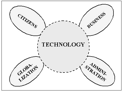
In the following there are a few examples on possibilities that the potential technological developments will offer to citizens, public administration, business and the ongoing activities within globalization. Citizens look for experience and adventure. They will expect that all information independent of where it is stored will be available at their fingertips present as well as historical versions 24 hours a day. Some day self-administration and self-service will be taken for granted. Therefore it is urgent and necessary to combine the information systems with actual and updated knowledge. This will not be limited to traditional e-commerce. In a near future it will be possible for the citizen to update information stored in the different databases via personalized portals. The geographic based information systems will directly or indirectly influence the way that the public administration is organized. With access to all data and knowledge it will become possible to supply as well the politicians as the citizens with the same information as the case officer and it becomes possible to decentralize decision competence. Because it will be possible to combine data from sources, even sources on different levels in the administrative hierarchy it will be possible to break down traditional bureaucratic barriers even barriers between the private and the public sector. Spatial information will be one of the catalysts in reengineering of many administrations. Systems like this demands common references, common "keys" between different data sets, seamless databases, common standards etc. Spatial data or information stored in traditional paper maps is static. Each map sheet represents a snapshot of selected objects at a given time, and "the owner" has an exclusive right to the map and the data the map is based on. In contrast to this a digital map or better a collection of spatial and spatial related data is dynamic with the time parameter as a part of the individual data collection. In "the digital world" we have a situation with different owners of spatial data, many different users and an unknown number of applications. In this context it is not possible to maintain a traditional hierarchical marked. In stead we will experience a marked organized as a network with many to many relations. The users, as well public as private, groups or individuals, will take it for granted that it is possible to combine data from different sources. To handle this situation the geo information business has to be reorganized. We will see new business units based on partnership and strategic alliances. Some of these business units will be global. Internet and E-commerce is some of the catalysts in this process. There is a general trend towards being Global. Agenda 21 and The Habitat II Global Plan of Action address the need for information, development of appropriate databases and exchange of information as conditions for creating the basis for sustainable development in all regions of the world. One reason for this is that the global society faces great problems concerning urbanisation and the influence of urbanisation on coastal zones and environmental conditions overall. The ongoing development includes globalisation of both environmental problems and trades. CHALLENGESThe technological development will continue and the possibilities for handling spatial data and information will proceed. When we are looking at the data and the formalized procedures for creating models of our physical surroundings, visualization of the results etc. the situation is different. There are a number of recognized and not recognized obstacles. The major hindrances are completely organisational. Against a background of a large number of presentations in Prague and in Athens in 2000 and the belonging discussions and debates the chairmanship has formulated the following draft on "Experiences and Visions" concerning spatial information management. On the one hand this is not a scientific conclusion based on uniformed data, on the other hand there was so many similarities in the different statements that the "Experiences and Visions" is normative for the necessary developments in the years to come. Experiences
Visions
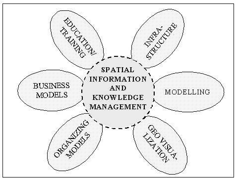
An examination of the "experiences and visions" shows that the sub-statements can be divided up into five groups: Infrastructure including data modelling
In addition to these five groups it is reasonable to extend the list with an additional group:
As mentioned in the preceding paragraphs it will become necessary to include knowledge or access to knowledge in the future spatial information systems to make the systems usable for ordinary users. The time has come to speak about "Spatial Information and Knowledge Management".
There are a several sub-themes in each of the six groups. To support a holistic development of spatial data and information you need to concentrate on a few but very essential activities. Each of the groups will be illustrated by examples. In "Experiences and Visions" you can find advice on how to make progress within Infrastructure and the fundamental concepts of National Spatial Data Infrastructure (NSDI). Independent of the level of development data modelling is a fundamental topic within NSDI. To secure harmonizing and the possibility of combining data from different sources you have to agree on common methods and standards for data modelling. Even though it is very conflict-ridden it is necessary on cross-institutional level or better on national level to start to discuss and decide on the semantics in spatial data. Depending of the maturity of NSDI in the individual country it is in addition recommendable to have special focus on issues like standards, especially the ISO standards for Geographic information, legal aspects, access to data and prizing. It is very urgent to relate the different topics to the Internet as a mean of communication and to e-commerce. The term modelling comprises several very different areas important for professional handling and presentation of spatial data and information. Presentation of data from one or several databases and sources requires decisions on how to select and how to manipulate data to be able to express what you want to express. In this context the methods are model generalization and cartographic generalization. Both methods need to be developed to a degree that it becomes possible to carry out the procedures "on the fly". The last area to be mentioned here is modelling of our physical surroundings including the related attributes combined with tools for analysing of the models or changes introduced into the models. Traditional spatial data and information has been visualized on one specific media, paper. In line with that PC's with access to the Internet has become widespread it has been obvious that visualization of spatial data and information on a screen is very different from visualization on a map. It is partly due to the size of the screen, the presentation of colours, the possible minimum size of objects on the screen and similar differences. There is a strong need for examples and standards for visualization of spatial information, geo-visualization, on traditional maps and on screens including the small screens on hand-held devices. Because many new users only have limited or no experience in use and interpretation of spatial based information it is necessary and urgent to develop alternative possibilities for the presentation and interpretations of spatial information, including integration of knowledge. As soon as it is possible to have simultaneous access to different sources with spatial data and if possible even knowledge it is time for reengineering of the way we arrange duties, workflow and decision making process inside the individual organisation and across boarders between different organisation including boarders between private and public administration. At the same time it is a part of the organisational framework to co-operate on the implementation of as well a National Spatial Data Infrastructure as possible co-operation on regional and even local level. As illustrated previously in this paper the marked for maps and spatial data and information undergo major changes at the moment, with Internet and E-commerce as business drivers. To day the producer specifies the content and the quality of the available product. To morrow we will see quite new products specified by the customers dedicated to specific use. Normally the products will consist of data and information from different sources eventually as results of modelling processes or results from customer defined analyses done by a service provider. Changing from a situation where the national mapping agencies almost had a monopoly to a marked with a widely distributed supply chain demands new business models, new prizing algorithms, clarified rules for copyright, standardized product specifications and access to Meta-data and it demands partnership and strategic alliances between the possible players in the spatial information arena. The traditional employee with a medium or high-level education in geo-related issues does have a comprehensive knowledge on IT and informatics, cartography, photogrammetry and surveying. At the same time there is a need for employees with new qualifications such as management, standards, data models, meta data, access to data, infrastructure architecture, intellectual property right, copyright, prizing of data and organizational developments. Beside there is a need for knowledge on analysis, modelling, visualization, visual communication etc. The new technology offers completely new possibilities for training and education. Distance learning and distance training are becoming important strategic issues in developing countries and countries in transition because training and education on site will minimise implementation times. Besides it will be possible to be less dependent on key persons because it will not be costly to involve more employees in the training and education. THE ROLE OF COMMISSION 3A commission in the FIG structure is not able to have it is own research and development activities. In stead a commission can initiate and support research and development at universities, in developing organisations and private companies, and the commission can disseminate information and knowledge to FIG, the delegates, the member associations, to UN to the World Bank, to international aid-organizations etc. Commission 3 tries to live up to this. We collect information on the ongoing developments and developing trends in the different member countries through the national delegates and other involved in the commission network, from presentations during FIG working weeks and the annual meetings, from best practise studies, by interpretation of the answers on questionnaires and from monitoring the developments in different countries and regions. On background of a continuous registration of the trends and the strategic plans for FIG formulated by the Bureau and adopted by the General Assembly it is possible to come up with a working plan for the commission for an inter-congress period (four years). The working plan comprises sub-working plans for working groups, plans for annual meeting, communication plans etc. After a period (1998-2002) with very much focus on National Spatial Data Infrastructure it is time for going deeper into some of the other elements within the framework of Spatial Information Management: modelling, geo-visualisation, organizing models, business models and education and training. Now it is up to the incoming chairmanship and the active delegates of Commission 3 to decide on the content of the work plan for the period 2002-2006. My recommendation should be to concentrate the energy of the Commission on organisational and business models combined with aspects of NSDI, modelling and geo-visualization and spatial knowledge management. CONTACTJes Ryttersgaard 14 April 2001 This page is maintained by the FIG Office. Last revised on 15-03-16. |