PROMISING STEPS TOWARDS AN INTERNATIONAL ON-LINE SERVICEDr. Szabolcs MIHÁLY and Katalin TÓTH, HungaryKey words: on-line, real-time service, up to date administrative boundary data, interoperability, ABDS for the CEEC project. 1. INTRODUCTIONThe transition towards the Information Society - it is the challenge of the new Millennium. Geographic Information Systems play a special role in forming the new infrastructure, as 80% of any kind of information can be linked to its location by direct or indirect positioning. For a big deal of users the co-ordinate systems are too specific. Indirect positioning, e.g. linking the information to administrative territorial units suits much more users' requirements. Administrative territorial units can be represented by their boundaries; the addition of attributes widens the circle of interest to them. The registry of boundaries, the data capture and compilation of the administrative boundary database is generally the task of the national mapping agencies and partly those of the statisticians, all representing a part of the National Geographical Data Infrastructure (NSDI). The globalisation and the increasing number of cross-border co-operations require unified interoperable data for any region. This awareness led to the creation of SABE (Seamless Administrative Boundaries of Europe) by the European mapping agencies and then - as a kind of geographic extension and in the same time a technological innovation - the ABDS for the CEEC (Administrative Boundary Data Services for Central and Eastern European Countries) project. 2. ADMINISTRATIVE BOUNDARY DATA AS PART OF E-GOVERNMENTProvision of reliable up-to date basic data infrastructure is generally the task of the government. Nowadays this task is even more important, when the transition towards the Information society takes place. The overwhelming amount of data however require systematisation which can be for example thematic ones such as databases for different sciences and disciplines, or for everyday use (e.g. timetables of different means of transport). Another approach is offered by the Geographical Information Systems (GIS) where the base for systematisation is the linkage to the location. Co-ordinates fully define the location, by direct way. However these entities are meaningful only for a certain circle of the users. For the everyday user and for a number of types of information the location usually means indirect positioning, e.g. a settlement, a region, or a whole country; in one word an administrative territorial unit. Naturally, the administrative territorial units are represented by the co-ordinates of their boundaries, meanwhile these data may remain hidden for the user. The Administrative boundary data - being the base information infrastructure for different kind of analysis when spatial reference is required - are core part of the NSDI. The number of potential users is practically indefinite, range from statistics to economic analysis, from environment to logistics, from business administration to marketing, etc. A wide spread use of such kind of information can greatly contribute to modernisation of the whole infrastructure of a country, or a region. The provision and integration of such data and services seems indispensable for the modern electronic governance. But what are the key requirements for such a service? Firstly, the service must be reliable. It means that it must
exactly reflect the actual legal status of the territorial units.
Secondly, it must be relatively cheep and accessible for a wide range
of users (with certain products to be served for the public free of
charge). Finally, it must be interoperable in respect of merging the
different data sources as well as user friendly such that the user
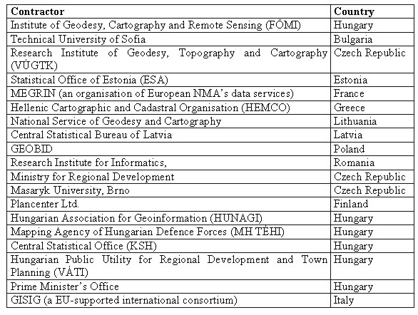
could specify the product wished to purchase. 3. ABDS FOR THE CEEC PROJECTAs preparatory phase of a future service, the ABDS for the CEEC project, supported by the INCO Programme of the European Commission was launched on 1st December 1998 and was finished on 31 December 2000. "The project aimed at the preparation and partial implementation of on-line delivery of administrative boundary data collected, processed and delivered with defined rules for data model and products, using the new European and ISO standards". It was intended to support the data collection for the existing datasets of similar content (e.g. the topographic map based SABE). The project was co-ordinated by the Institute of Geodesy, Cartography and Remote Sensing (FÖMI), Hungary and was implemented by a consortium of 19 organisations from 12 countries, representing the national mapping agencies, statistical offices and other public and private organisations of the region as given in the following table.
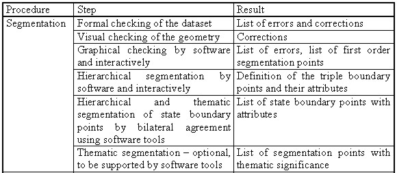
The task of the project was elaborated in three main work packages - Inventory, Generalisation and Memorandum of Understanding - accompanied with the horizontal activities of standard conformity checking, quality assurance, and legal protection. The geographically scattered project team was supported by modern on-line facilities of information technology like document handling system, internet conference, and web-based voting. The work packages were divided into tasks, which were strictly planned both in content and timescale. The interactive working methodology of collaboration guaranteed on one hand a creative environment for original ideas and on the other hand a critical control mechanism and feedback. 4. RESULTS OF THE INVENTORYThe objective of the first work package was to clarify everything about the input of a future service. For this purpose the consortium compiled a questionnaire where the following questions were answered in details:
The research showed us, that the possible source for the ABDS varies from country to country. In some countries data are registered and maintained in the cadastral offices, while in certain countries such precise registers do not exist at all, administrative boundaries are presented on topographic or other maps. The kind of source of AB data greatly defines the accuracy and influences directly on the largest possible resolution of the service. Therefore, each country can join the service depending on the quality of their available data. Consequently, as a result of the inventory we defined the so-called consolidation levels which can serve as data of basic resolution to be used for different products of the common ABD service:
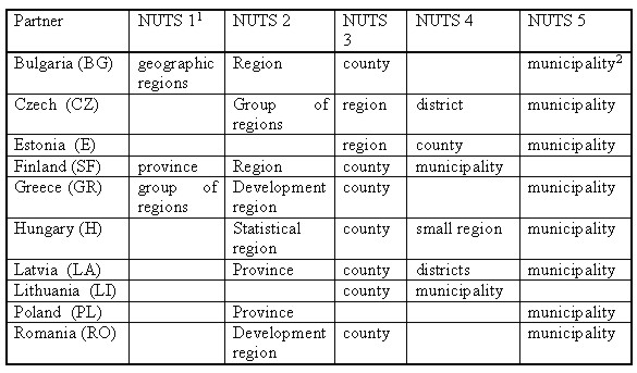
The hierarchy of administrative units varies from country to country. However the international character of the future service requires some possibility for comparable handling. The NUTS (Nomenclature of Units for Territorial Statistics) system of EUROSTAT created for similar purpose is quite suitable. In the following table we give the summary on the administrative hierarchy of the participating countries of the project as compared to the NUTS:
1) NUTS 0 level is assigned to the country in case
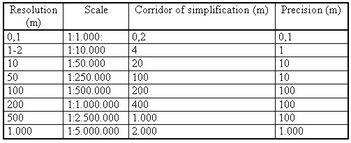
of every participants. 5. THE RESULTS OF GENERALISATIONThe objective of this work package was to elaborate generalisation rules for the ABDS using a model oriented approach, formulating the requirements, coming to agreement on scales/resolutions and elaborating recommendations on the base dataset derivation. All with the aim to give the answer to the question on how we can convert our data into a product. Since the objective of the ABDS for the CEEC project is to deliver digital datasets of the administrative boundaries and not to produce maps, a model generalisation approach has been decided to be used rather than a cartographic one. That means in fact a simplification procedure using well elaborated and accurately tested algorithm(s). In the model generalisation process a geometry driven approach is applied. The elements of the consolidation level database then derived from the elementary datasets of administrative boundary data and then delivered by the specialists of the respective country itself. The commonly used method of production guarantees the unified quality all over the area of participating countries. This method is to
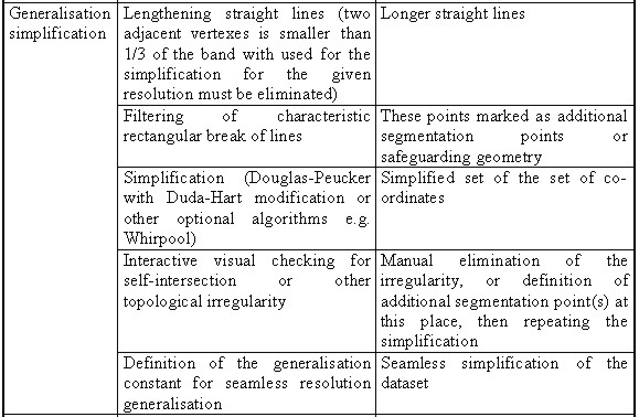
The steps of the model generalisation and their results are given in the table below:
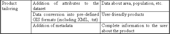
The experience of the project partners (FÖMI with Hungarian Administrative Database (MKH) and MEGRIN with SABE data base) showed that majority of customers liked to purchase standard products rather then to order something more specific. Therefore creation of a standard product line seems to be reasonable, which can greatly accelerate the on-line service. These products might be generated beforehand so the customer could download it immediately. The project consortium agreed on the following content of the standard product line:
It was also agreed, that for better satisfaction of customers the delivery of other types of product also would be possible. In such case the customer might specify its request on-line, while the product will be delivered in several days later depending on the complexity of the request. Such individual product might be prepared in any case and using any simplification method, and also attaching any available attributes. The customer will be informed about his/her possibilities, and also will be given a short demonstration of the results of the different possibilities, all on the international portal. 6. THE ABDS DATA AND SERVICE MODELThe results of the country inventories and the generalisation gave input to the data model of the service, which was elaborated in several iterations, through clarifying the data content, considering the output of the future service and investigating the technical possibilities for practical implementation. The data content, data model, service model and metadata descriptions has been elaborated conforming with the existing GI standards. To provide a common service of geographic information the data must be managed seamlessly in space and time as well as standardised by their content, structure and format. Requirements to the service portal and the data flow must be precisely formulated and correspond to the principles quoted bellow:
The service model foresees the following products: gazetteer, free of charge products, standard (catalogued) products, customised products and value added services, as well as providing the data in national projection systems, in 2D geographical coordinates of ETRS'89 (GRS80 ellipsoid) and in data formats of dominant GI softwares. In practical terms it means a separate data collection in every country in accordance to the strategic principles, the technical specifications and other adequate local running project in the country. The collected data will form the elementary database of the country, which must be transformed then according to the specifications elaborated in the generalisation work package of the ABDS project. The consolidation level database is forwarded to the international focal port (international ABD portal) in order to be merged with data of the other partner countries. The change management procedure is very similar to the initial data collection, with the difference that only change files are to be supplied to the international portal (change management procedure). 7. ON-LINE SERVICE OF ADMINISTRATIVE BOUNDARIESThe master databases are stored on the server of the national portal in each country. Depending on the technological possibilities the database system can be fully, or partially distributed. The national portals will communicate with the international portal, which is intended to consist of two units, the data server and the client server. The client server will provide the facilities or browsing, querying and ordering the standards products, and also will contain a module for individual ordering, according to the specifications of the user. The theoretical achievements if the project were tested in frame of the pilot service based on Hungarian data. In Hungary the source of AB basic data is the national cadastre of the Hungarian National Agency on Lands and Mapping. Data of more than 3200 settlements are stored and maintained in the nation wide network of 116 Land Offices. Therefore the initial step for the pilot service was to collect these data from the cadastral registers. The existing intranet, called TAKARNET between the Land Offices and the FÖMI made possible the easy information transfer to FÖMI which is the National Focal Point with national and provisionally international portal. The Hungarian ABD master database then was compiled according to the specification fixed by the project consortium. We developed as well an uploading module for ensuring the communication between the data and client server. In order to fulfil requirements of interoperability, for map browsing we tested an XML/VML based software Axiomap 1.2 which is commercially available and very cheap. Besides of the map based browsing the Axiomap offers possibilities for different queries based on the attached attributes. We included data about the area of the territorial units, the population, housing, etc. taken from the Hungarian Central Statistical Office. We provided a gazetteer type searching unit too. For the better orientation of the client metadata descriptions were included as well. A prototype of the pilot ABD services elaborated on the Hungarian example has been presented successfully at the project closing review meeting in Prague, January 18-19, 2001. 8. MEMORANDUM OF UNDERSTANDINGThe project was finalised by the signature of the Memorandum of Understanding at the Prague closing review meeting. It describes the technical, organisational, and some other aspects of the future service. It regulates the relationship between the SABE and the future ABDS. The ABDS will be not a competitive product to the SABE, but rather a complementary one, as regarded the geographical scope, the technological innovation and the resolution of the data to be supplied. On one hand the experience of SABE in managing of such kind of databases, on the other hand the geographical and resolutional extension and the technological innovations of the ABDS open together a good base for joint thinking and actions at European level, too. 9. CONCLUSIONThe "Administrative Boundary Data Services for the CEEC project implemented a work in harmony of general trends of Geographic Information Infrastructure and the Information Society. Its main objective, to define framework for implementation of a new ABD service in the region was achieved. The innovative approach - on comparing with other existing services of the same character - was expressed in the following fields: Using administrative boundary data with legal background rather than the topographical ones of secondary data source
Besides of the innovation described in details in this report the project has some more positive results:
The positive experiences of the pilot project have proven, that we took a promising step towards the implementation of a modern international on-line service of the base data infrastructure. Our results were highly appreciated by the European Commission. The public report of the results of the project "ABDS for the CEEC", including the names of representatives of participating countries and organisations, can be visited web site. BIOGRAPHICAL NOTESzabolcs Mihály Academic experience: Dipl. Photogrammeter-Surveyor
(Institute of Geodesy, Aerial Surveying and Cartography, Moscow,
1967), Doctor Tech. (Budapest Technical University, 1982), Ph.D.
degree (Hungarian Academy of Sciences, 1981) Katalin Tóth CONTACTDr. Szabolcs Mihàly Katalin Tóth 14 April 2001 This page is maintained by the FIG Office. Last revised on 15-03-16. |