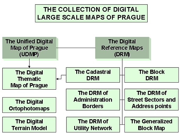
USERS OF THE DIGITAL MAPS OF PRAGUEDr. Jan BARES and Jiri CALEK, Czech RepublicKey words: digital map, users, Prague, overview. 1. COLLECTION OF DIGITAL LARGE SCALE MAPS OF PRAGUE (CDMP)The map basis as the most significant part of positioning information is the necessary tool for organization and authorities, providing the municipal administration, development and public service. Due to the absence of a unified and maintained map base, the city management decided (in 1980) to solve this problem. As a result, a specialized workplace was founded in 1985 to ensure the creation, updating and maintenance of maps based on computer technology. Since 1991, the Institute of Municipal Informatics of Capital Prague (IMIP) has been charged with these services. The Collection of Digital Large Scale Maps of Prague (CDMP - pic. 1) rose step-by-step beginning in 1987. At present, the Collection consists of the Unified Digital Map of Prague (UDMP), Digital Reference Maps (DRM), Digital Ortophotomaps (DORT), the Digital Thematic Map of Prague (DITEM) and the Digital Terrain Model (DTM). The UDMP (scale 1:500) is the most extensive and detailed large-scale map of the Prague area. It ensures the content relationship between the cadastral map, technical map and the documentation of utility lines maintained by utility managers. The accuracy of the map is defined by the mean position error mxy=14 cm. In order to make use of the valid cadastral map, a mutual 5-year agreement between the City of Prague and the Czech Office of Geodesy and Cadastre was signed in 1986. The subject of this agreement was the mutual and coordinated development, maintenance and use of the UDMP as the part of the Municipal Information System as well as in the Automated Information System of Geodesy and Cadastre (AIS GK). The reassumed agreement was concluded in 1994. In 1993, the agreement of cooperation between the creation and updating of the UDMP and the creation of information systems of counterparts was signed. From the 14 original signatories, the number culminated to 58. This agreement ensured the mutual exchange of the data free of charge. The utility managers agreed, with the condition that after finishing the UDMP in particular cadastral areas, they would authorize the position and routing of their object; the municipal offices ensured that the present of the Real object state documentation to IMIP will be the part of the building permit procedure (one of the most important sources for updating the map). The UDMP creation process began in 1987 and by the end of 2000 was 86% completed for the Prague area. The continued update runs since 1993. The Set of Digital Reference Maps (SDRM) consists of the: DRM of Administration Borders (DRMA), the Cadastral DRM (CDRM), the DRM of Street Sectors and Address Points (DRMS), the Block DRM (BDRM), the DRM of Utility Networks (DRMU) and The Generalized Block Map (GBM). The creation of the SDRM proceeded from 1993 - 1996, its scale is 1:1000 with the position error of 28 cm and it covers the whole Prague area (496 km2).
DORT consists of black and white ortophotomaps created only in the 1996 nonvegetative period, (1 pixel ~ 20 cm), spectrozonal ortophotomaps (1996, 1 pixel ~ 40 cm) and color ortophotomaps (1 pixel ~ 30 cm) updated every year either for the northern southern Prague area. DTM was created in 1996 as the base for ortophoto rectification. It is commonly used for the scale 1:5000. The origin of this model is the photogrammetrically estimated network of control points in a distance of 30m and terrain braking lines. From this base, the contour lines were generated for the entire Prague area. DITEM was created for the demands of users as the reduced content of UDMP and CDRM In 2000, the evolution of the graphical database MAPA3® was completed, providing the common source of the map data with unified updating lines for all graphical systems. This year, the work on the digital model of estate (DME) began. The use of this model is estimated to be in the architectural modeling, environmental and wireless communication sphere. In addition to maintaining and administrating map datasets, IMIP ensures other services for the municipal administration. For example, from 1992-2000 IMIP helped the municipal offices with the system of municipal land property evidence. On a monthly basis, IMIP delivers the data of descriptive parts of cadastre from the Prague cadastral office to the municipal offices. The main goal is to reach mutual connectivity of the map types with a unified updating process and with outputs that completely respect the user demands and needs. CDMP is financed from the city budget. The cost for creating, updating and administration of the datasets reached $12.7 million. (From this, 54.5% for cooperation and development, 36.5% for maintenance and 9% for investment costs). The cost for map creation was $7.7 million and for updating $5.0 million.
Picture 1. 2. DATA PROVIDED FROM CDMPIn the very beginning of the digital map creation process, when the technology only allowed batch processing on a main frame computer, the main goal was to create the primary data and to ensure the interest from the side of the municipal organizations.
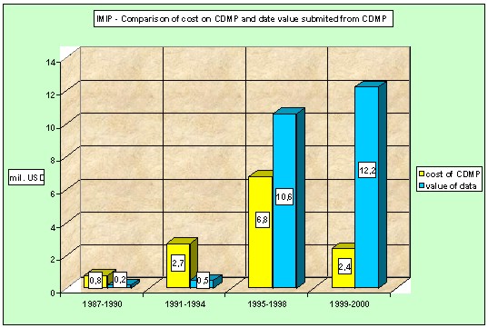
The progress of cost and data value can be seen on Pict. 2. At present, the total value of CDMP data output ($23.5 million) significantly outweighs the cost for creation, updating and data management ($12.7 million). Picture 2.
3. THE USERS OF CDMPFor providing data, the rules and pricelist are determined by the city council resolution. The data can be delivered to:
In fact, four groups of users exist in Prague:
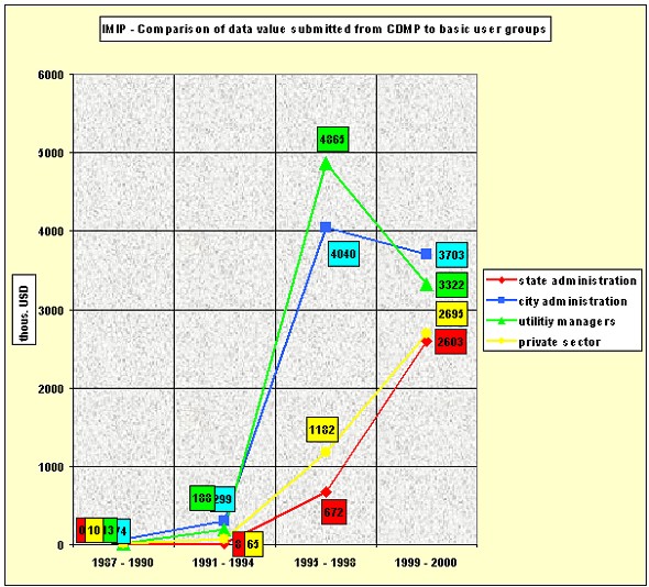
Picture 3.
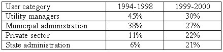
As can be seen on Pic.3, it is obvious how the interest of individual groups for CDMP outputs progressed. Up until 1994, users could have the outputs from UDMP only. At that time, 14% of the Prague area was completed. The interest was outweighed from the side of utility managers and the municipal administration. In the period 1995-1998, interest rapidly increased due to the finished DRM, DORT (since 1997) and UDMP (completed for 64% of the Prague area). As in the previous period, the most significant users were the utility managers, who started to build their own information systems. In addition to these activities, the data delivery to the municipal offices increased (Prague has 57 municipal parts). In 1993, 15 municipal offices used the CDMP data. In 1996, however, the number rose to 45 and presently 56 municipal offices use the data. The interest from the side of state administration and universities was significantly influenced by the combination of the UDMP and DORT. The main customers are financial offices, the Ministry of Finance, the Ministry for Regional Development, the Czech Office of Geodesy and Cadastre, the Czech Statistical Office and the Office of the Czech President. From the universities, the users are mainly the Faculty of Architecture and the Faculty of Civil Engineering of the Czech Technical University in Prague. The interest in the private sector increased slightly, but since 1996 it represents the highest growth. Finally, the private companies could afford the appropriate HW and SW equipment. It is quite interesting to compare the relative shares of the user groups in the total data amount:
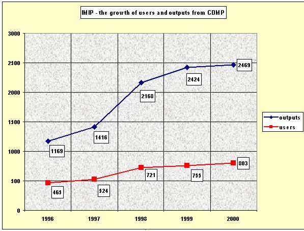
Picture 4. Growth of the number of users and outputs (jobs)
CONTACTRNDr. Jan Bares Dipl. Ing. Jiri Calek 22 April 2001 This page is maintained by the FIG Office. Last revised on 15-03-16. |