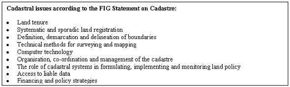
CADASTRE AS A TOOL FOR IMPLEMENTING LAND POLICYProf. Tommy ÖSTERBERG, SwedenKey words: Cadastre, land policy, land reform, land consolidation, land acquisition. AbstractStarting from the FIG Statement on the Cadastre which defines the cadastre as an information system for rights, use and values of real properties, the paper will highlight the importance the cadastre has as a tool for land reforms in the Scandinavian countries. Based on that, the paper will also comment on which role the cadastre is playing for land reforms in South East Asia, e.g. Vietnam and the Philippines and in Southern Africa, e.g. Zambia and Mozambique. One conclusion will be that the cadastre in the Scandinavian countries not only has been an information system, but also a tool to promote economic and social development through land reforms. Similar development can be seen in other countries. The cadastre can be an active tool to support land reforms in many other countries in the world in order to promote social and economic development in a sustainable manner. CADASTRAL STATEMENTFIG has issued a cadastral statement, which was adopted 1995. Besides questions related to the cadastre as a land information system about rights, use and values of land, the statement identifies a number of cadastral issues. Among these issues are "The role of cadastral systems in formulating, implementing and monitoring land policy", which includes the following:
LAND REFORMS IN RURAL AREAS OF SWEDENThe interest for land reforms and other types of political influence on the use of land has varied over time. In the old days, the government has always shown a keen interest in land use and how land use rights have been distributed. Agriculture was the far most important land use and how land were cultivated was of extreme importance for the social and economic development of the country. The government had also a more pecuniary interest since the land and especially the agriculture production was an important base for land taxes. The government policy tried to counteract fragmentation of land and instead encourage young people to seek new land for new development. This was the main land policy for many years and the tool to implement the policy was mainly the cadastre. The cadastre provided information on land use and values, which was the base for the taxation. The cadastre also provided information on how land use rights were distributed and thus allowing the government to influence how the land rights were divided through administrative regulations. A typical regulation could be that a cadastral unit was not allowed to be split up in parts, whose value was under a certain limit. However, these types of regulations were not very effective. The old type of parcelling included a split of every field among the owners in a village. This type of parcelling together with increasing populations lead to a more and more fragmented situation in rural areas. The government then formulated a policy to actively counteract the situation through comprehensive land consolidation procedures that in a systematic way was carried out throughout Sweden. Not less than three consecutive reforms were carried out during the period from 1750 to 1900, the latter more radical than the previous. The tool to carry out these reforms was a cadastral procedure, which was based on the skill of the land surveyor to measure the size of the field and to carry out the valuation. Based on this information it was possible to document the value of each property and elaborate a new plan where the value of each property increased, due to a better parcelling structure. From beginning more technical, the procedure developed also into a legal procedure, which gave the land surveyor the authority to decide, under certain conditions, when the land owners could not agree on certain matters regarding the consolidation. The decision of the land surveyor had the same authority as a court ruling. In fact the cadastral procedure became the first instance in the court system regarding land. During the 19th century, liberal ideas spread in society and influenced among others the land policy to large extent. Restrictions on land use, ownership, subdivision or amalgamation where more and more abolished and the land market become more and more a free and open market. The peak of this development occurred around 1900. The free market on land contributed in many ways to the industrialisation and the early urbanisation of the country at the same time that the ongoing land consolidations greatly improved not only the productivity in agriculture, but also considerably extended the area of cultivated land. This area was three-doubled during the period of land consolidation. The policy started to change towards more regulations in beginning of the 20th century. The reaction started in the forestry and was caused by big forest companies buying large tracts of land for cutting, thus depriving the rural land owners of their long term mean of survival. A prohibition of companies buying forest land was established. Instead the companies had to buy the wood from the farmers. The industrialisation lead to urbanisation and demand on new land for urban development. On the other hand, the rural population, although rapidly decreasing in number, needed to have similar possibilities to improve its economic situation as the urban population had. It was therefore necessary to continue a rural land policy, which facilitated continued consolidation processes of farm and forestry land. Another reason was that the two World Wars in the 20th century have shown that it was not possible for a country to trust the world market for food supply. During the wars, the market was cut off and the country had to rely on domestic food production. The land policy for rural areas was now formulated to support increased improvements of the size and shape of farms that could support one family and give them equal income opportunities as industrial workers. This was implemented with a land distribution control through the cadastral legislation, which included regulations both on size of suitable farms and of who were allowed to buy farms or buy additional land to increase the size of a particular farm. Farmland could only be bought by persons, who were occupied or had a suitable training and knowledge, and who in principle were family based farmers. The legislation excluded for instance companies or big investors from buying land as well as non-active interests, for instance personal recreation. In order to facilitate land consolidations and extension of existing farms, the government established itself as a land buyer and created land banks, which were distributed to interested farmers. In this way, the government, through the acquisition control, and through active buying, could greatly influence the development of prices on land. Low prices of land was desirable to keep the prices of food down and also the governmental subsidies on food as low as possible. This policy was successful, since it contributed to increased size of the farms and allowed a reasonable income development for farmers, in comparison with other groups in society. Today Sweden has joined the European Union and its outdated agriculture policy. There is no more any governmental interest to uphold the rural land policy except for in some remote areas with very thin population. The free market has once again been established for rural land and it is open for everyone, whether Swedish citizen or not. LAND REFORMS IN URBAN AREASUrbanisation was rapid in Sweden for a period of about 100 years from 1870 to 1970. Since then the speed in urbanisation has decreased, although the tendency towards more and more concentration of the population to bigger and bigger urban conglomerate is continuing. In the beginning, urban development was mainly carried out by private investors, buying land and constructing real properties for residential, industrial or service purposes. After the Second World War, there was a considerable neglected demand for housing together with an economic boom. The democratic systems had been strengthened by the victory in the wars and the interest to promote political ambitions through urban development, like to prevent segregation in housing, promote equal access to public and private services, to provide good housing standards at low costs etc. The policy gave the local governments, the municipalities the responsibility to actively provide good urban planning and good housing for the increasing urban population. The central government supported the municipalities with legislation and financial means through subsidised state credits. The legislation was mainly cadastral and urban planning legislation. The urban planning legislation established that the municipality had the exclusive monopoly to decide where, when and by whom an urban development project should be carried out. The municipality should acquire enough land for urban development. Controlling the major part of the land market for urban development gave the municipality a dominating influence of the development of the land prices and speculations in development. Urban planning could be carried out with less attention to landowner interests and more in creating good living conditions from social and environmental point of view. Land thus found suitable for urban development was allocated to private developers or to public housing companies. The competition on land was replaced by a competition among developers of different kind on land provided through the municipality. In order to facilitate for the municipality to acquire land for urban development a number of legal tools were introduced in the cadastral legislation:
CO-OPERATION BETWEEN REAL PROPERTY OWNERS, -JOINTLY OWNED FACILITIESThe modern society demands more and more complicated forms of interaction between its members at different levels. Central and local governments are there to solve a lot of the interactions, but cannot solve all types of problem. The old village structure in rural areas has lost in importance and new demands on co-operation occur. The Swedish cadastral legislation provides a modern form for the establishment of co-operation between land users for a specific purpose, which in some way should be of stable need for the use of the individual real property (Act on jointly owned facilities). The co-operation can typically include roads, parking lots, playgrounds, swimming and recreational facilities, heating, water and sewerage, etc. The rights and obligations in the co-operation is organised as co-operation between the real properties. The co-operation is thus a real fixture to each of the member properties and thus independent of the owners personal rights. A jointly owned facility is established through a cadastral procedure, when it is decided who will participate, how the cost for construction and maintenance will be divided and how the facility should be designed. An association for the management of the facility will also be established. In similar ways, co-operation between land owners can be established through cadastral procedures to manage real property rights like fishing rights or hunting rights for bigger areas than the individual property. ACQUISITION OF RIGHTS FOR SPECIFIC PURPOSESNew development demands new rights to land use. Pipelines, power lines, roads, railways, cables and masts for tele communication, demands limited rights to land use. These kind of limited rights, similar to easements, are established in Sweden through a cadastral procedure. The procedure will define the right, if it is permissible and decide the compensation to the land owner. CADASTRAL PROCEDUREThe cadastral legislation, regulating the different forms of procedures is mainly the following:
The procedures in these acts are almost the same. The application is sent to the cadastral authority. The cadastral authority consists of one land surveyor and if needed two trustees. The authority will investigate the case. The investigation will include technical, economical and legal preconditions. The conditions that must be fulfilled protect both private interests and public interests. Any compensation to be paid among the participants in the procedure must be estimated and decided by the authority. Any participant in the procedure, who is not satisfied with the decisions, can claim the decisions to a special land court. The main difference between a cadastral procedure and a court procedure is that the cadastral surveyor in the cadastral procedure has the responsibility to carry out all necessary technical, economical and legal investigations. In a court, the parties have to make their own investigations and put forward to the judge for decision. The cadastral procedure is thus much faster, more participatory and less costly than court procedures. Besides Sweden similar cadastral procedures can be found in Finland and partly in Norway. CADASTRE AS A TOOL FOR IMPLEMENTATION OF LAND POLICY IN VIETNAMThe Vietnamese land management system is based on State ownership to land. The policy since independence has to great extent included the creation of co-operatives for land management. This policy started to change in beginning of 1980ies when the co-operatives started to lease land to its members on a contract basis. In 1987 a land act was approved, in which the State started to allocate land for long-term and stable use by households, individuals and organisations. The right allocated is connected to purpose for which the land parcels is to be used, for instance agriculture, forestry, residential or different kinds of special use. The length of the allocation is different for different purposes, from 20 years to infinity. The land users enjoys the five rights, which are, right of transfer, inherit, lease, exchange, mortgage, The land allocation and registration is a cadastral procedure for which the land administration branch on different levels, from central to communal level is responsible. The process includes technical issues, to demarcate, survey and classify the land, legal, to check legal conditions and to check that taxes and fees are paid. The actual valuation and calculation of fees and taxes is done outside the process. The land use planning, which in principle is a prerequisite for the land allocation is also carried out by the cadastral organisation. The land reform has been very successful in agriculture and contributed to much increased agriculture production-It has also contributed to secure wood supply to the paper mill in Bai Bang and to several plantationsh and protection of forest needed for environmental protection. There are still some demanding problems that need to be addressed by the reform, some of them have to do with the conflict between traditional rights to extensive use of land compared with more intensive (shifting cultivation towards cash crop farms). In urban areas the land registration process has not really started to influence the reality. This means that the urban land market is in principle informal, although mostly within the control of local authorities.
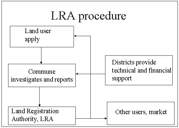
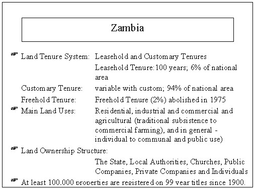
Proposed new procedures for land administration in Vietnam THE LAND REFORM IN THE PHILIPPINESThe Comprehensive agrarian reform on the Philippines is mainly the responsibility of the Department of the Agrarian Reform (DAR), but include also a number of other agencies. The land tenure should be improved through better access and more equitable distribution of land and the fruits thereof. The welfare will be enhanced and delivery of support services to farmers co-ordinated The land tenure system is improved through programmes such as Operation Land Transfer (OLT), which is a programme for compulsory acquisition of land for redistribution to tenants, and voluntary offer to sell and transfer programmes. The functions of DAR includes identification of beneficiaries of the programme, acquisition of land for redistribution, preparation of compensation, fixing lease rental contracts, survey of resettlement areas and provision of a number of support services including legal assistance, information and education, land consolidation etc. The background for land reform in the Philippines is the very uneven distribution of land rights where most farmers are tenants on big estates. The reform has gone on for long time during different governments with different success. However, during recent years it seems to have gained new momentum. In the Philippines the cadastral system is equal to cadastral surveys, which are only partly being carried out by DAR in resettlement areas. But the whole concept of DAR and its involvement in the land reform represents, besides the extension services to farmers, what could be considered as a cadastral issue according to the FIG definition. CADASTRAL SYSTEM IN MOZAMBIQUEMozambique has recently applied a new land policy based on the land law from 1997. Dinageca with provincial offices are primarily responsible for the implementation of the new land law. Many wars and other disturbances have forced people in Mozambique to move a lot. Both traditional land tenure systems as well as formal systems are under stress and in disorder. People are moving back to original places or founding new unoccupied land to cultivate. Since there are a lot of abundant fertile land in Mozambique, there is also an interest from investors to invest in farm development at rather large scales. These demands on investment opportunities are of great importance for the economic development in the country. The Mozambique government had the challenge to define a system, which could balance the demand for investment opportunities against traditional rights and the need for small scale farmers to get access to land. The cadastral system has been designed to give the framework for solving these conflicts of interests, if any. An investor has to apply for land rights at the provincial cadastral office. This office will investigate and among others organise community consultations with the local community and any other persons, who might claim interests in the land in question. If there are doubts to which local community the land belongs, a community determination procedure can be started. In this procedure, the boundaries between neighbouring communities are determined. The community consultations will end up in a negotiation process, under which the conditions for the investment will be determined. This will in principle mean that the investor will be given a certain amount of land with agreed boundaries. In compensation the investor will have to give back some kind of compensation to the community, for instance in the form of improvements of schools, roads, power supply etc. The procedure is handled by the cadastral organisation and will end up in a land allocation, which include a title to the right to the land use. ZAMBIAThe new land law of Zambia (1995) defines among others a feature of the cadastral system, which probably will be important for the continued development of the country. To a land title, there is an obligation to pay a ground rent. This ground rent has been diversified to its amount and adopted to the paying capacity of different land users. In this way the ground rent is affordable for all land users with a title and can also be collected without to much difficulties. Part of the collected ground rents is put in a land fund. This fund is used to support improvement projects both in rural and urban areas. In this sense, the cadastral system in Zambia is in a constructive way contributing to the social and economic development of the country.
BIOGRAPHICAL NOTEThe author, Professor Tommy Österberg, is the Swedish delegate to Commission 7. He is also the chairman of the Swedish Association for Surveyors, Sveriges lantmätareförening. He has a position as Technical Director at Swedesurvey and has acquired a considerable experience from cadastral development projects in the world. CONTACTTommy Österberg 15 April 2001 This page is maintained by the FIG Office. Last revised on 15-03-16. |