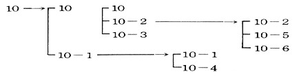
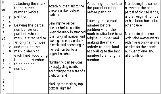
A HISTORICAL STUDY ON THE PARCEL NUMBER AND NUMBERING SYSTEM IN KOREAProf. Uknam KIM, KoreaKey words: land registration, parcel number, numbering system, Land Information System, cadastral history, reform reestablishment. AbstractAmong legal unit of land registration, the minimum unit of land is one parcel. We give the parcel number according to numbering system to confirm the specification of the parcel. In Korea, this parcel number is used for daily life such as the sign of fixed place (address) and the property, of the place of register, of identification card and of legal action. It also plays the important role as a key item connecting the layer of other information system in organizing Land Information System. It is also valued as the sources looking for the process of developing of the country. This study will devote to cadastral history, reform and reestablishment of the country. 1. INTRODUCTION1.1. PurposeThe land information system(LIS) which records and manages the land-related informations has been developed for the effective use and management of the land. By connecting each parcel on the surface of the earth in the modern city, better service for all kinds of infrastructure utilities (water supply, drainage, electricity, gas, communications, roads) should be quickly offered to the final users. As the efficient conduct of the works above is considered as an important official duty in the urban administration, the officials should make the most of LIS for the information exchange among the relevant sections, for the systematic conduct with better performance, for the integrated data management which is based on the digital and time-serial process. Having the technology of urban information system, LIS holds cadastral information, resident information, building information, road information, etc. These informations are connected with a parcel which is the minimum unit of the land. Each parcel is specified by its own number so named "parcel number". Parcel number with a sub number, in case of the occurrence of boundary trouble, has a role to choose the basic point for the survey on the map by distinguishing between the history of the divided land and the line on the cadastral records. Parcel number is the minimum unit by the work of land administration. If parcel number is logically managed, it plays a important role to relate text with graphic data, such as a primary key in database. This paper describes the form of the parcel number and the numbering system in Korea with the change of the times and offers the sources to establish the best possible model of the numbering system. 1.2. Study scope and methodThe Korea government has already completed the pilot project of cadastral re-survey and is now in preparation for legislative bill which includes the registering of buildings and underground facilities with parcel based in the six metropolitan cities from 2010 through the new system of parcel number. For offering the sources to national policy of land management, this study analyzes the change of the parcel number and its granting system in Korea and set the scope as follows. Chapter presents the purpose, scope and the method of the study as an introduction, chapter describes the parcel number and its granting system, chapter analyzes the change of the parcel number form and the system. Chapter presents the sources for the model selection of the best possible parcel number and its system in Korea according to the result of the analysis. 2. GENERAL VIEW ON THE PARCEL NUMBER AND ITS SYSTEM2.1. Definition of the parcel numberThe parcel number is a particular number alloted to a unit area to guarantee the particularity of the land and is a number given to each parcel as a registration unit. Every trade of the land is guaranteed only after the allowance of the parcel number. The most important reason to grant the parcel number is to distinguish the land and then to guess the location. The concept of an address used in everyday life is called as a lot number, but the parcel number has a role as a standard for communications, visitations and administration with the meaning of the particular location of the land. Therefore, the parcel number of the land has to be granted orderly and systematically for more convenient use. 2.2. Constituent element and type of the parcel numberThe parcel number is consisted of an original which is the particular number given to a unit area without a sub number such as 1, 2, 3, … and a sub number which is a new title defined at the cadastral law with the enforcement of May 7, 1976 earlier called as branch number or attached number. The sub number is written as -1, -2, -3, … and read as "dash one", "dash two", "dash three", etc. So, the parcel number is consisted of an original number only or at other times an original number with a sub number but it is not possible to make a parcel number with a sub number only. The parcel number with an original number only is called as "single parcel number", and the parcel number with an original number and a sub number is called as "double parcel number". The single parcel number is suitable for the large land and has been used both in the land survey and the forest survey in Korea. Also it is often used in the country which tries to establish a new cadastral system. The double parcel number is used for the parcels of new registered land and the divided land, and highly beneficial for the complex unit law. 2.3. Standard of the parcel numbering(1) Principle of parcel numbering The parcel number as a unit of parcel number area is established on the principle of the northwest numbering rule orderly starting from number 1 by the direction of northwest to southwest. (Enforcement ordinance of Cadastral Law, Article 3 clause 1) (2) Numbering due to an initial registration and so on It is established by attachment of a sub number such as -1, -2, -3, etc. to the nearest original number of a registered land in the relevant parcel number area in the case of initial registration, registration conversion, parcel number change, administration area change, etc., or an original number will be orderly established from the next to the last parcel number of the relevant parcel number area in the case of a remote land, the last parcel number in the relevant parcel number area, several parcels and vast area. (Enforcement ordinance Cadastral Law, Article 3-2, -6, Enforcement regulation of cadastral Law Article 4-2) (3) Numbering due to partition 1) The one parcel divided of a parcels is numbered by the same parcel number as before partition and the other parcels are numbered by attaching the sub number to an original number which is the parcel number before partition as like (figure 1).
Figure 1. Numbering system after partition 2) If the land owner applies by designating a certain parcel after partition as the particular number, the parcel which the owner wants can be numbered as (figure 2) after examining the reason. (Enforcement ordinance of Cadastral Law, Article 3-3)
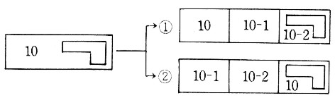
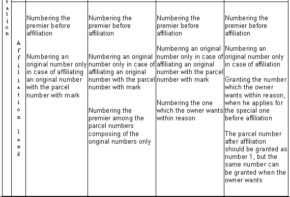
Figure 2. particular numbering system after partition The parcel number after partition should be granted like in figure 2, but it can be given like in (figure 2) when the owner wants to grant the parcel number to the land of residential building after partition according to the address number 10. (4) Numbering due to affiliation The front parcel number among the parcel numbers before affiliation can be granted like <table 1> or the prior parcel number which is an original number among the parcel numbers before affiliation is granted like <table 2>. When the land owner applies by designating the particular parcel number among the parcel numbers before affiliation, the parcel number which the owner wants can be numbered like (figure 3) after examining the reason. (Enforcement ordinance of Cadastral Law, Article 3-4) Table 1. prior numbering system after affiliation
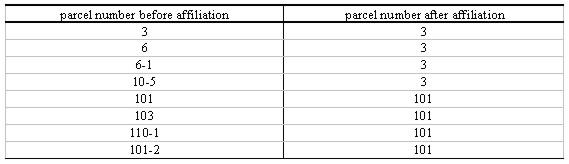
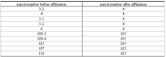
The parcel number after affiliation should be granted as address number 1, but the same address number (the parcel number in which the building was constructed) can be granted when the land owner wants.
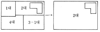
Figure 3. particular numbering system after affiliation Table 2. prior numbering system as an original number after affiliation
(5) Parcel numbering according to the land readjustment and so on
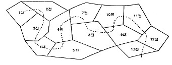
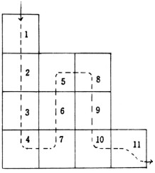
2.4. Method of parcel numbering(1) Classification according to the progress direction 1) Meandering method This method is granted to the area which is the parcel arrangement is not regular and the original number is continued in order according to the progress direction. It is suitable to establish the parcel number in the rural area. 2) Odd and even numbering method The odd number will be granted to one side of the road and even number to the other side. It is also called the reciprocal method and is suitable for granting the parcel number in the urban area.
Figure 4. meandering method
Figure 5. odd and even numbering method 3) Block method One original number will be granted to each block and one sub number to each parcel in the block. It is suitable for granting the parcel number in the land readjustment area, the cultivated area and so on.
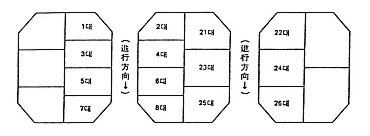
Figure 6. block method (2) Classification according to the unit established 1) Area unit method This method is to grant the parcel number in order for the whole area of one parcel number. It is suitable for the small area of one parcel number or the area which does not have many sheets of the cadastral or forest map. 2) Map unit method One area is subdivided into cadastral map unit or the forest map. The parcel number will be granted in order according to the order of map. It is suitable for the large area or the area which has many sheets of the cadastral or forest map.
Figure 7. area unit method
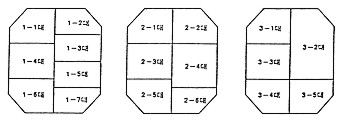
Figure 8. map unit method 3) Block unit method The parcel number is granted orderly to the whole area of one parcel number. It is suitable for the small area or the area which does not have many sheets of the cadastral or forest map. (3) Classification according to the numbering location 1) Northeast numbering method This method is numbering from northeast to southwest in order and is suitable to establish the parcel number in Chinese characters. 2) northwest numbering method This method is numbering from northwest to southeast in order and is suitable to establish the parcel number in Arabic numerals. 2.5. Characteristics and roles of the parcel number(1) Characteristics of the parcel number The land indication should have the characteristics such as accuracy, simplicity, uniqueness, flexibility, economy and accessibility. The land has the characters such as immovability of location, individuality and so on, and is subdivided into each parcel. The different number is given orderly to each parcel subdivided in each parcel number area and thus it has accuracy and uniqueness. Each parcel in the same parcel number area is given different numbers and thus it has accessibility to distinguish one parcel from the other. Each parcel is specified by the number assigned. Thus each parcel in each parcel number area is guaranteed to have specification by its parcel number and so the parcel number has the uniqueness. In addition, because the parcel number may have the same number of the parcel number as the number of parcel number area without indication of the parcel number area, it is difficult to guarantee the uniqueness of each parcel by the parcel number without indication of the parcel number area. It also has simplicity and economy to divide and combine the parcel number area. Especially, in case of computerization of land registration, this discerning factor is called integration key. (2) Roles of the parcel number The location and the border of every land in Korea has been established by cadastral survey. The location of land is discerned by relative location in everyday life rather than absolute location concept by coordinate. The relationship between human and location has many connections in law. The parcel number indicates the location of permanent domicile, resident registration domicile, present domicile, property location, place of an act, address, residence, office, place of business, etc. If there were not the parcel number, we would have a lot of troubles and problems in social and legal activities. Thus the location of every land should be indicated clearly, and the form of the parcel number and numbering system should be established in proper way.
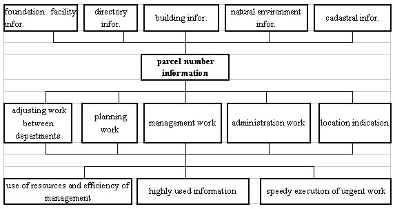
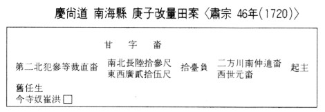
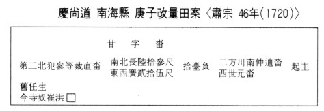
Figure 9. The concept of parcel identification number use for establishing the urban information system (The association of Japan Surveying Technology, 1989) Land (forest) register, real estate register and land record computerization are also enforced according to each parcel number. The parcel number plays a role as common item or key item of each layer related to land in the use of computerized information for land information construction and multipurpose cadastral system. (Figure 9) is to analyze the possibility of materials and information exchange using the parcel number between U.I.S (urban information system) and other institutes. It is reasonable to record and indicate the items on land according to each parcel number. Thus the parcel number plays an important role to plan and enforce the land project. 3. CHANGE OF PARCEL NUMBER AND NUMBERING SYSTEM IN KOREAIn each period such as before land survey (1910), from land survey to 1960's, 1970's, after 1986, the form of parcel number and numbering system is classified and studied focusing on comparative analysis of standard to establish parcel number, parcel number composition, sub number area, sub number direction, land alternation. 3.1. Parcel number and numbering system before land survey (1910)We can reach conclusion that there was no parcel number system because of no records on parcel number from ancient times to the middle of Koryo. By enforcement of Kwajeon Law at the end of Koryo, land register and parcel number (Ja ho) system had been started to establish to grasp the concrete condition of land. Parcel number system was adopted at the period of King Gongyang(1345~1394) and by this, numbering system defined 'Jung' as land establishing area to classify every land within Jung up to one thousand Jung from Chonjajung, Jijajung to Yajajung in order of the Thousand-Character Text. Jung was divided into 20kyol, 15kyol, 10kyol, etc. according to military service condition, and land register was made by Jung unit and land owner's name was written after putting character & number to Jung. Later the form of land register by Kwajeon Law became the turning point from the early or middle period's person centered arrangement to the material centered arrangement according to each parcel number (Ja ho) by Jung unit. In Chosun period, character-number was granted to each parcel in order of the Thousand-Character Text according to the order of Yangjeon to indicate the condition of land. Character-number was consisted of characters and numbers, and one character of the Thousand-Character Text was granted to per 5kyol regardless of Paekyungjeon, Kikyungjeon. It was the so-called 1 character 5kyol system. It was started to discuss from 24-year of King Injo(1569) and later it was enforced in full scale for the project of Haeseoyangjeon at 35-year of King Sukjong(1696). The land was classified according to each owner by numbering No.1, No.2, No.3, etc. within one character of The Thousand-Character Text. Its character meant the area of land and was same with the area establishing parcel number, and its number was same with the present parcel number. In case land improved after character-number had been already granted by the enforcement of Yangjeon, the previous character-number in Yangankijae was used without change for its character-number. When there was a new land after Yangjeon branch number was attached to character-number of its adjacent land and so this means there was sub number system to establish parcel number in Chosun. At the end of Chosun, however, when Yangjeon official improved land, he could change the previous character-number. In this case, the reason to change character-number, that is, words such as old Chonja new Jija, etc. should be written in the column related to land in Yangan. Especially, in case the character distorted by deliberate change, land of new Joho could be checked by old character-number by comparison old with new Yangan. For example, <table 5>is cited from No.14711 of old document Yangan in Kyujangkag. Table 5. Kyungsang-do Namhae-hyun Kyungja Yangan improved (Sukjong 46 year-1720)
Table 5>is a part of Jeonan which was Kyungsangdo Namhaehyun Kyungja improvement. It uses Kamja meaning the character-number of the Thousand-Character Text, No.3, No.4, No.5, etc. for parcel number, Seobum and Dongbum for the direction of Yangjon, Samdeng and Sadeng for the grade of land, Jik for the form of land and dap for land category. Table 6. Kyungki-do Kwachon-kun Haseo-myun Yangan (Kwangmu 4 year-1900)
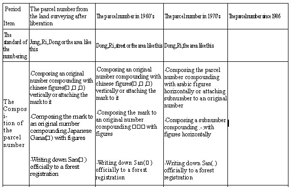
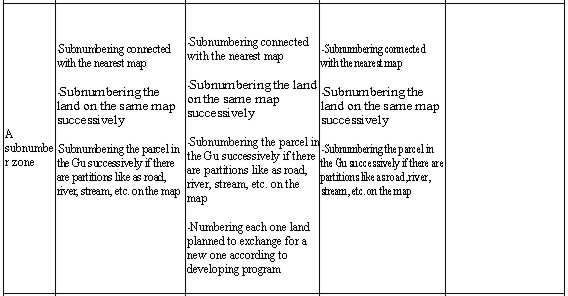
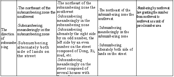
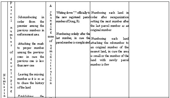
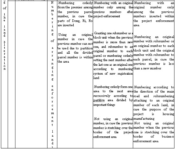
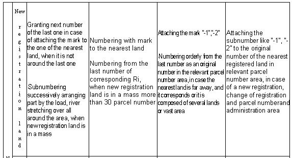
Table 6 is Yangan of Kyungkido Kwachonkun Haseomyun, and here Danja is character-number of the Thousand-Character Text and No.18 is parcel number. In addition, land border in the four quarters was indicated by drawing four marks. 90 and 40 in the rectangle means that the length of land between south and north is 90 chuk and the width of land between east and west is 40 chuk. Yangjiomun was abolished on September 9, Kwangmu 1 year (1901) and Jikyeomun was established. In `Daehanjekuk Jeondapkwanke', the character was used to indicate the parcel number. There was the land report of group survey in each Dong and Ri and each parcel carried by investigation on land ownership of Chosun land survey as its major project. Character number in this report and Kyolsuyonmyungbu refer to parcel number and this character number is found in Wondojupsokillamdo numbering to each parcel in the survey. The first cadastral map was made in March, 1911 and thus the parcel number was recorded in the cadastral map for the first time. There is a record that people paid fees according to the parcel number when the first cadastral map was published in 1918. Also we can find the parcel number in forest survey document by Chosun Forest Survey in 1924. 3.2. The parcel number and its numbering system from the land survey to the presentThe various forms of parcel number and its numbering system from the land survey in 1910 to the present are as follows in (table 7). Table. 7. Historical form of parcel number and numbering system
4. CONCLUSIONAs a conclusion, the various types of parcel number and numbering system in Korea are summarized as follows.
BIBLIOGRAPHY
CONTACTProfessor Uknam Kim 15 April 2001 This page is maintained by the FIG Office. Last revised on 15-03-16. |
||||||||||||||||